Midweek Nor’easter storm impacts and timeline
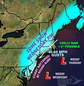
The polls are closed, the votes have been counted, and it’s time to project what is going to happen when a Nor’easter arrives on Wednesday. This storm, although not nearly as big as Sandy, is going to be a headache for many from the Mid-Atlantic to New England. The storm will rapidly intensify Tuesday night and Wednesday morning. It will be tightly wound, with some strong winds wrapping into the storm. The storm will bring snow and rain to the Mid-Atlantic and Northeast, and some of the heaviest snow may fall New Jersey, a state that is still reeling from Hurricane Sandy’s major impact. As the storm intensifies, it will churn up some significant waves, and a minor storm surge that will likely lead to minor to moderate coastal flooding along the Atlantic coast.
- Check the Interactive Radar for the latest on the storm
- There will be a live blog for Right Weather Pro members Wednesday afternoon
Storm Timeline for Southern New England
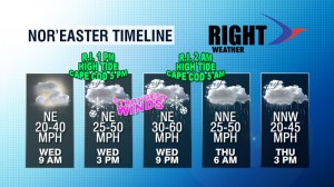
Clouds will stream in quickly by dawn Thursday, and rain should reach the coast by mid to late morning. The rain will spread inland by noon, and as it comes down heavier, a change to snow is possible in the Providence area, and likely in the highest terrain of Northwest RI, interior CT, and MA west of I-495. Moderate to heavy rain, mix, and snow will continue into Wednesday evening. If there is snow in the Providence area, it should change to rain by late in the afternoon, with little, if any, accumulation. The snow may hang on for a few hours longer in NW RI, and an inch or two may accumulate on the grass. The best chance of seeing more than 2″ is north and west of RI. Rain will continue off and on through Wednesday night and Thursday as the storm slowly spins out to sea south of Block Island and Nantucket. The wind will be a big factor near the coast from Wednesday afternoon through Thursday. The storm should move away from Southern New England by early Friday morning. It will be very raw, with the temperatures staying in the 30s and 40s through the duration of the storm.

Storm Impacts in Southern New England
Snow
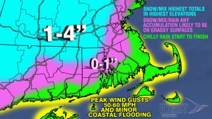
This won’t be a huge snowmaker for Southeastern New England, but many of us will probably see the first flakes of the season flying on Wednesday afternoon. It’s unlikely that the snow will stick in areas outside of the highest elevations of NW RI. The highest snow totals in Southern New England will be in the highest elevations from Worcester County through the Berkshires. These areas could pick up 3-4″ of wet, heavy snow. NW RI may pick up 1-2″. It’s also unlikely that travel will be particularly hazardous because the temperature is going to be in the 30s, and the ground is not frozen yet.
Rain
There will be a burst of some moderate to heavy wind-driven rain Wednesday afternoon and evening, but the storm will not be a super-soaker. Most areas will pick up 0.75-2″ of rain from midday Wednesday until late Thursday night. That amount of rain, spread out over nearly 40 hours will not lead to any flooding.
Wind
The coast will see the strongest winds. Peak wind gusts will likely be 50-60 mph for Cape Cod, the Islands, and, possibly, Buzzards Bay and the RI coast. Those winds aren’t nearly as strong as Sandy’s peak gusts, but they are still strong enough to down some branches and power lines. Isolated to scattered power outages are possible. Peak winds away from the immediate coast, including Providence, should be in the 35-50 mph range.
Coastal Flooding
Minor coastal flooding is likely during the high tide Wednesday afternoon in RI and Wednesday evening on Cape Cod. It will not be nearly what was experienced during Sandy. It should be the kind of splash-over flooding that occurs a few times a year during similarly strong storms. The beaches will take another pounding with rough surf likely into early Friday before the storm departs.

Storm Impacts in the Mid-Atlantic
The Mid-Atlantic was hardest hit by Hurricane Sandy, and some of the residents who are still without electricity will be dealing with the same kind of howling winds and wintry mix or chilly rain that will hit Southern New England. Some of the highest snow totals from the storm are possible in SW NJ and near Philadelphia where several inches of heavy, wet snow could fall. Minor to moderate coastal flooding is likely on the same shores that were decimated by Sandy. New York City may get some snow, but the temperature is likely to be at or above freezing, so heavy accumulations are unlikely before a change to rain late Wednesday.


