Monday morning update
The latest trend with the midweek storm is to keep colder air locked in place, especially inland. While this does not mean an all snow event, it does mean that there could be some snow at the start of the storm in the hills of NW RI, NE CT and Worcester County. It also means that NY and NJ stand a better chance of seeing some snow. It still looks like a raw rain from start to finish in Providence, Boston, and near the coast. This is a computer model trend we’ll continue to monitor, but the overall forecast has not changed. The biggest difference since we first gave a detailed forecast late last week is for the temperature during the storm to be in the 30s/40s instead of the 40s/50s.
From Sunday night
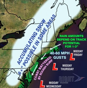
The week will begin with some clear and cool weather, but wholesale changes are coming by late Wednesday. We’ll be dealing with a nasty Nor’easter Wednesday night into early Friday. The storm is likely to bring a myriad of lousy weather and weather-related impacts, including some heavy rain, strong winds, and rough seas and surf capable of more beach erosion and minor to moderate coastal flooding. The storm will have the biggest impact in the areas that were hardest hit by Hurricane Sandy just a week ago.

Both Monday and Tuesday in Southern New England will be dry and cool. Highs will be in the 40s. Monday will be partly sunny, and breezy, with highs in the mid to upper 40s. Monday night looks like the coldest of the season so far. Lows will be in the mid to upper 20s. Tuesday will be bright, but brisk and cool, with highs in the low to mid 40s.
Wednesday will start with some dry weather, but it will end with a wind-driven moderate to heavy rain. Highs will be between 45-50. Wednesday night into Thursday morning looks rough, with wind, rain, and some rough surf and possible coastal flooding. The storm will be a slow-mover, so more wind, rain, and coastal flooding is possible through Thursday night into Friday morning. Temperatures will be in the low 50s in far Southeastern New England, but may stay in the 40s to 30s from Providence to Boston and northwest. Check out the video for more details on the storm.


