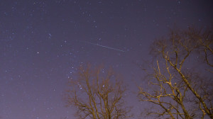
I really hope you had the chance to step outside Thursday evening to check out the Geminid meteor shower. I’ve witnessed a few meteor showers in my life, and this was by far the best one I have ever seen – especially considering that I just stepped out the back door and looked up! The sky was exceptionally dark and the stars were bright with a new moon. There is a fair amount of light pollution near my house in Bristol, but within seconds of stepping outside with my 11 year old son at 10 pm we saw a meteor. Within five minutes we saw a half dozen. I went back out about an hour later and set up my camera on a tripod to, hopefully, capture a shooting star. I took about 30 long-exposure (20-30 seconds) shots on a manual setting and was pleasantly surprised when I checked them out on the computer and caught a nice streak on just one of the shots. I can’t imagine how great the show must have been in a really dark location where the stars were bright and the edge of the galaxy is visible with the naked eye.

It will be another quiet day with highs in the 40s in most spots. A few may touch 50 degrees briefly this afternoon. Skies will be mostly sunny. Tonight looks clear and cool, but not terribly cold, with lows ranging from the mid 20s to the low 30s. There will be a nip in the air Saturday, and it will stay dry, with highs in the low 40s under a decent dose of sunshine. The rest of the forecast looks pretty active, and hear are some thoughts on what we can expect in the following week.
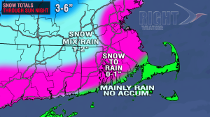
Sunday snow/mix/rain to rain
- Snow and rain are likely on Sunday, with a chance of minor accumulations well inland
- The precipitation will get steadier as the day progresses
- If it starts as snow near the coast, there will be a quick change to rain. It may not even start as snow within 5-15 miles of the coast or bay
- The best chance of snow accumulation that doesn’t get washed away is in the Berkshires and well north of the MA Pike
- All of RI and SE MA will see a change to rain by Sunday night, and it will remain chilly and raw into Monday morning with temps in the upper 30s to low 40s
- The weather doesn’t look great for the Patriots-49ers game in Foxboro. Any snow should change to chilly rain with temps in the upper 30s to low 40s

A look at next week
- The forecast is still rather uncertain for next week
- We know it will be pretty stormy, with some rain likely for Southern New England early in the week
- A storm will form close to the coast on Monday into Tuesday
- Rain, may be heavy at times, Monday night into early Tuesday
- The mountains of Northern New England may pick up a foot or more of snow before Wednesday
- Some backlash snow showers may move through RI and SE MA Tuesday night into Wednesday morning
- A break in the action is likely in the middle of next week from Wednesday afternoon to Friday morning
- The computer models are indicating another storm for the Northeast next Friday and/or Saturday
- There is a slightly better chance of snow in SNE from that storm, but the track is still very uncertain
- There has been a lot of inconsistency with the computer models for next week’s weather due to the uncertainty of handling the timing and intensity of jet stream energy that is thousands of miles away right now
- In general, it will be colder from the middle of next week through Christmas
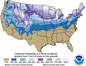
- The odds of a White Christmas are historically about 25-40% in RI and SE MA
- Based on the current pattern, I think the odds are just slightly higher this year – between 30-50%, with the 50% odds inland


