The weather pattern will remain active for the rest of the year, with three separate precipitation events possible in New England before New Year’s Day. The broad scale weather forecast has been fairly consistent for the past few days, but the devil is in the details as the storm’s tracks vary significantly from one computer model cycle to the next. It will be a quiet end to the weekend, and Monday looks fairly quiet for any last-minute Christmas shopping. Both days will be seasonably cold, with highs in the upper 30s to low 40s. Sunday should be partly to mostly sunny, and after a sunny start Monday, clouds will roll in by late in the day.

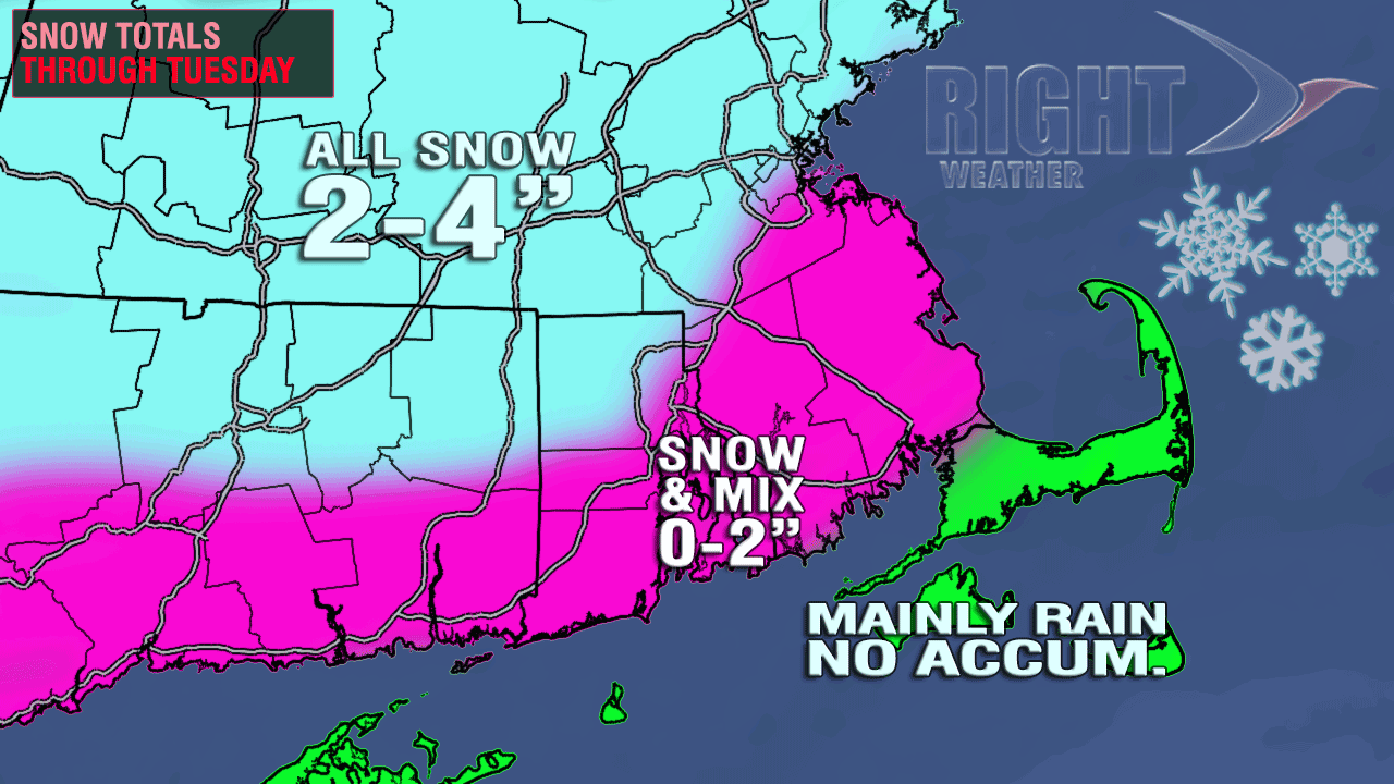
A fast-moving system will bring some fairly light precipitation to the Mid-Atlantic and New England Christmas Eve into Christmas Day. Right now, it does not look like more than a nuisance storm, with the hardest hit areas picking up 2-4″. Below is a forecast accumulation map released to Right Weather Pro members Saturday morning.

At this point, I’m leaning toward the lower end of the totals, which would not make for a white Christmas near the coast of Southern New England. After analyzing Saturday’s information, the only change I would consider is lowering the high end totals to 1-3″ because some of the latest information suggests a very limited moisture supply for the storm. Because it’s not a large or intense storm, the exact track will be critical since there will be a relatively narrow swath of accumulating snow.
Christmas Day may start out with some snow/rain, but any precipitation should end by midday. The afternoon looks partly to mostly cloudy and cold, with highs in the mid to upper 30s. There will not be a long break between weather systems, and another storm will already be forming over Texas and Louisiana on Christmas morning. The track of that storm should go from the Southeast to the Ohio Valley before it redevelops near the coast or over the Atlantic Ocean. Where that storm redevelops will be critical in determining what type of precipitation it brings to Southern New England.
Right now, it appears the redevelopment will be too close to the coast for an all-snow event in a good chunk of Southern New England – including Providence, Boston, and coastal areas. At this point, it is too early to throw in the towel on a track that’s farther offshore and colder, but the odds are favoring a track that brings the heaviest snow to Northern New England. Based on the current projections, the precipitation will begin late Wednesday and last into midday Thursday, with the worst weather likely Wednesday night.
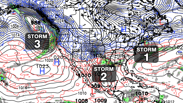
More cold air will flow in as that storm departs, and a third storm may already be making it’s way through the Western United States Thursday afternoon. Of course, if the track of the Wednesday-Thursday storm is uncertain, then determining the track of a storm that may hit the Northeast sometime late next weekend or into the New Year is not possible. Computer model projections range from a big, snowy Nor’easter to another “inside runner” that puts all of Southern New England on the mild side of the storm. While it is tough to pin down the details of the 5-10 day forecast, it is actually easier to discern a long-range pattern that will likely bring very cold weather to the Eastern United States for the start of January.
The bottom-line is I’m confident in some areas of the Northeast picking up 1-2 feet of snow in the next 10 days. We’ll spend the next 4-5 days figuring out who gets the snow and who, if anyone, gets the rain. It’s an active and progressively colder pattern that will continue into the New Year.
[/signoff]


