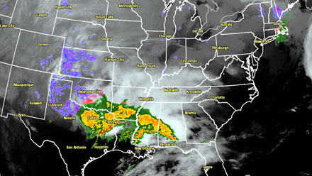

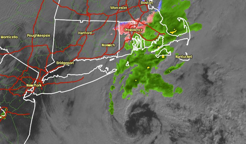
As the storm turns north into the Mid-Atlantic it will drop heavy snow on the north and western side of the track, with a wintry mix changing to rain on the east flank. The center of the storm will move over Southeastern New England, and there will be a myriad of weather hazards from wintry to windy to wet in all of Southern New England.
The weak storm that left a coating to an inch of snow in much of Southern New England on Christmas morning was moving east on Tuesday afternoon, and the rain/snow mix was slowly coming to an end. The temperature will fall below freezing Tuesday evening, and some icy spots are possible on any untreated roads and sidewalks. Sun will give way to clouds by late Wednesday as the large storm begins to move through the Mid-Atlantic states. Highs will be in the mid to upper 30s.
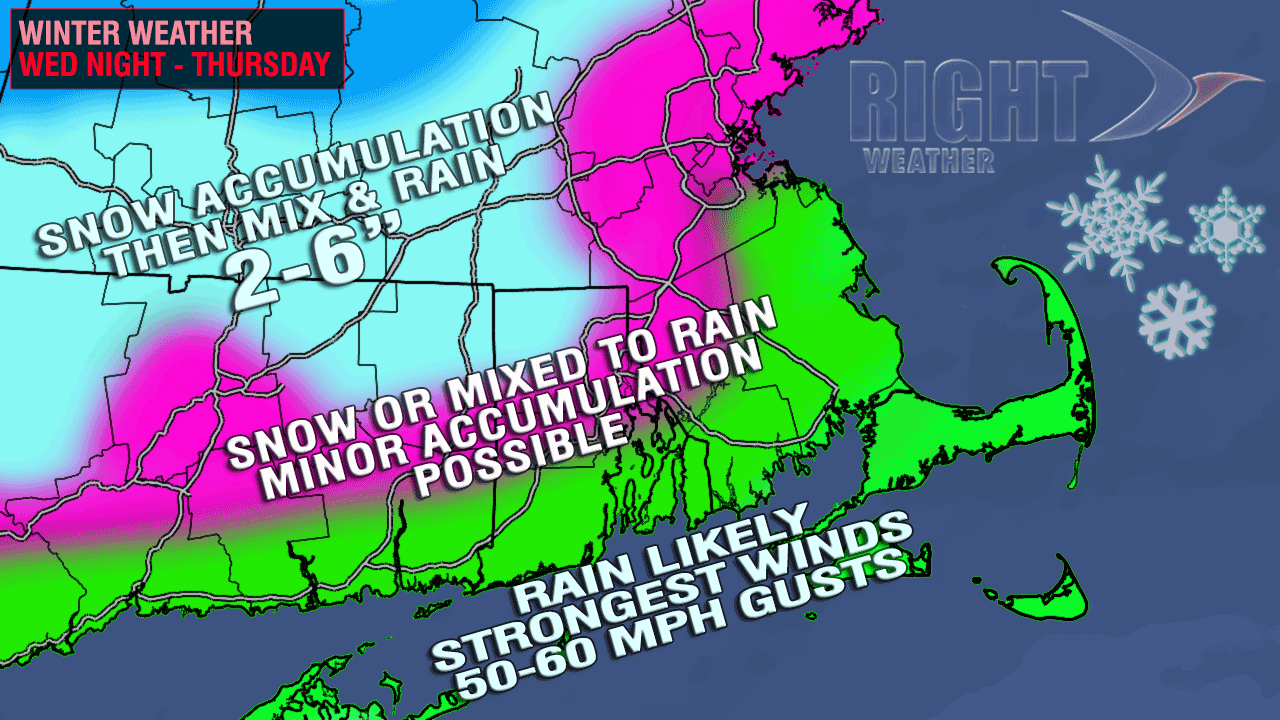
The storm will arrive with some wintry precipitation for all except the coast Wednesday night. The cold air will hang on for a while in northwest RI, interior CT, and central and western MA. As a result, several inches of snow may accumulate in far NW RI, Worcester County, and NE CT. It is very tough to know exactly when the snow will change to sleet or rain, so the forecast is for 2-6″ of snow, with the highest amounts likely in the highest elevations. Here is a look at some of the storm hazards:
- SNOW/ICE – Cold air will be stubborn inland, and travel may be tough from late Wednesday evening until before dawn Thursday as a burst of moderate to heavy snow and sleet hits areas well northwest of the I-95 corridor. In the I-95 corridor, a brief period of snow/sleet is possible before a change to rain. Any accumulation in the I-95 corridor should be minor and washed away quickly by moderate to heavy rain and rising temperatures.
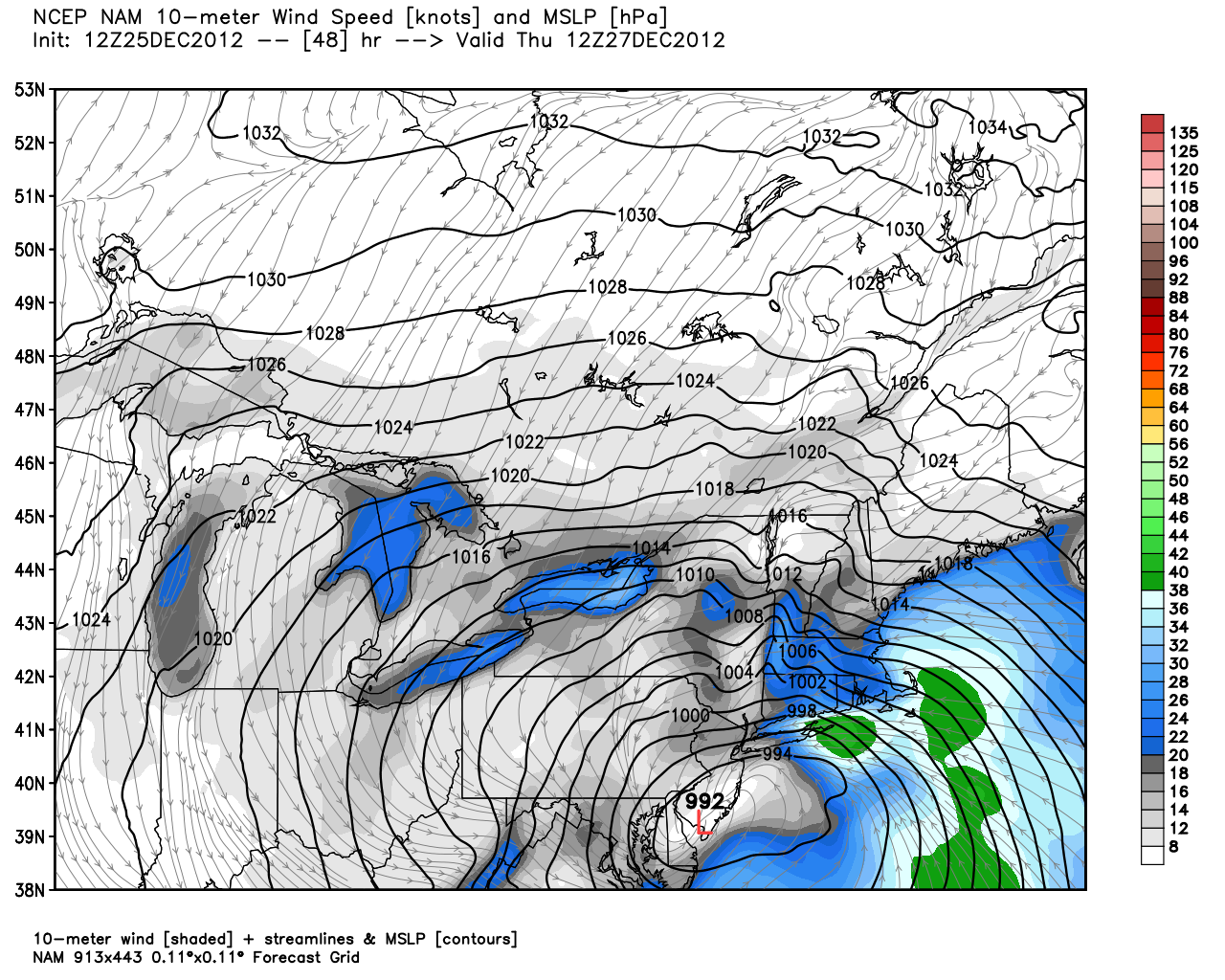
- STRONG WINDS – This storm has the potential to bring some very strong easterly winds to the coast of New England. High Wind Watches are posted for the coastline. Peak winds are likely from midnight to noon, with some 50+ mph gusts possible. Sustained winds near the coast should be between 25-45 mph. The wind speeds should be similar to what occurred on Friday, but the peak wind direction will be different. Friday’s strong winds were south-southeast, the strongest winds early Thursday will be out of the east.
- HEAVY RAIN – The storm should bring 1-2.5″ of precipitation to Southern New England. Some minor street flooding is possible, especially in the areas that received a couple of inches of snow followed by heavy rain.
- SKI AREAS – More fresh powder is in the forecast for all Northern New England ski resorts. The totals from the storm should be between 8-16″, with a few locally higher amounts possible.
Temperatures will be wide-ranging Thursday morning as the storm passes Southern New England. The islands and Cape Cod should see the temperature spike into the upper 40s to low 50s. Near the coast, it will be 45-50, in the I-95 corridor it will be in the low to mid 40s, and it will stay in the 30s inland. Western MA to Worcester may not see the temperature rise above 35 degrees.
The weather following the storm will be fairly quiet Friday and Saturday. Another storm will have an impact in the Mid-Atlantic and New England Saturday night into Sunday. There is better potential for that storm to bring snow to all of Southern New England, but the forecast has greater uncertainty because it is several days away.
Have a Merry Christmas!


