The latest storm has left many snow-loving Southern New Englanders longing for more than was delivered as a brief burst of moderate to heavy snow transitioned to a chilly rain by late Wednesday night. In many places, there was little evidence Thursday morning of the 1-2″ of snow that fell Wednesday evening. The temperature jumped well into the 40s in RI and SE MA melting some of the snow, and about an inch of rain helped to wash away the rest of it.
Thursday afternoon will be mostly cloudy with a few lingering showers. The temperature will fall from the 40s to the 30s by late in the day, and some of the last showers in Southern New England Thursday evening could be in the form of snow, but no accumulation is expected. The wind will pick up out of the northwest to 15-30 mph, helping to usher in the colder air Thursday night.
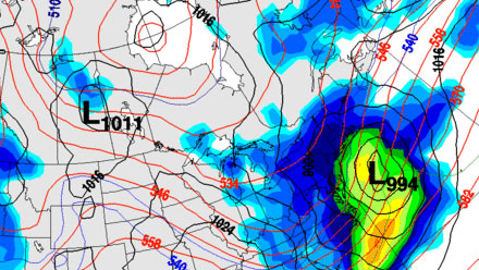
The break between storms will be a short one in Southern New England. Friday should be mostly sunny, brisk, and chilly. The temperature will be in the 20s at dawn, and rise into the mid 30s around midday. It will stay dry through Friday night as the next weather-maker gets organized in the Southeast while heading for the Carolina coast. There is a rather large discrepancy in the computer model solutions for this storm given that it is just two days away. A consensus track has the storm moving just far enough offshore to spare Southeastern New England a 6″+ snowstorm. It is still within the realm of possibility that the storm tracks 50-100 miles farther northwest than currently projected, bringing a significant snow to areas that received mainly rain from the last storm. An early outlook is for 1-3″ of snow for most of Southeastern New England, but that may need to be adjusted based on the projected track of the storm. The current forecast is for light snow to break out on Saturday afternoon and continue into the night, ending before dawn Sunday.

In any event, cold air will move in on Sunday and stay through the New Year. The high temperature on Sunday will struggle to get to 35 degrees. An Alberta Clipper will drag an Arctic cold front through New England early on New Year’s Day. The weather that follows will be bitterly cold, with some models indicating near-zero low temperatures Wednesday morning. It looks like a safe bet that the temperature will drop into the low to mid teens by dawn Wednesday, and it may not reach the mid 20s in the afternoon.
While the snow was changing to rain in Southern New England, it was piling up in Northern New England. The ski resorts are in great shape this week with another 6-10″ on the ground by midday Thursday, and it was still coming down. Check the Right Weather New England Ski Reports page for the latest, including a look at the cool, new interactive Freshy Map.
Ten inches of new snow! And yes, it's still snowing @KillingtonMtn pic.twitter.com/KT8cF9Oq
— Killington Resort (@KillingtonMtn) December 27, 2012
PHOTO: 8"+ as of 12 p.m. here's a shot from Illusion this morning #powderday #NH pic.twitter.com/CMQCJUiH
— Attitash Mountain (@AttitashResort) December 27, 2012


