Today in Southern New England was about as “Monday” as it can get. Damp, dreary, and in some cases raw and icy. The cold air stayed wedged into interior New England, leading to snow in the mountains of Northern New England, and some ice accretion Central Massachusetts. The freezing rain and drizzle glazed over trees and power lines leading to some downed branches.

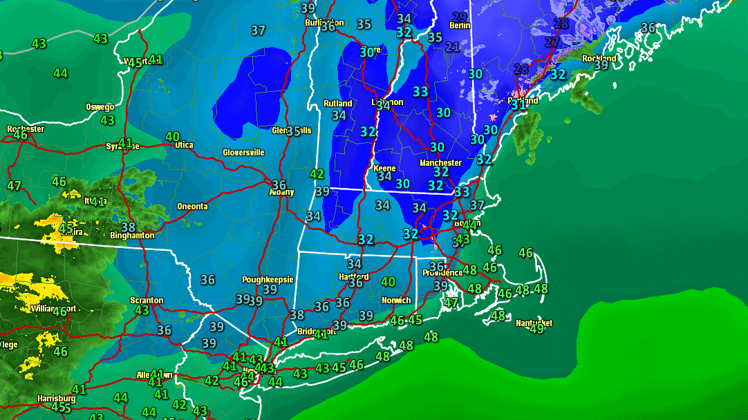
 In Rhode Island, the temperature gradually rose through the 40s near the coast and was getting close to 50 by mid-evening. Inland RI was still seeing temperatures between 35-40° at 8 pm. Some locally dense fog is possible overnight, and rain showers should return by dawn Tuesday. The temperature will slowly rise into the upper 40s to low 50s in all of Southeastern New England Tuesday morning. The steadiest showers should move through by midday, but clouds will be stubborn through the afternoon. The temperature will fall back into the mid 40s by late in the day, and will continue falling into the low 30s overnight. Skies will become partly cloudy with an increasing westerly breeze at 10-25 mph Tuesday night.
Dry and cool midweek, rain Friday
Wednesday and Thursday will both be dry, with seasonable conditions. The highs will be in the low to mid 40s, and lows will be in the 20s Wednesday night. The wind will be stronger on Wednesday, with some 35 mph gusts possible as the storm intensifies while moving away from New England. Another storm will be moving through the Tennessee Valley on Thursday, and that will lead to an increase in cloud cover by late in the day in Southern New England. The storm will take a track to the west of Southern New England, putting snow on the ground from the Midwest to the Adirondacks to the mountains of Northern New England.Southern New England will be on the mild side of the storm, and more rain and briefly mild temperatures can be expected on Friday. Mild weather is nothing new this December, and not just here in New England. Some parts of the country are experiencing and even warmer month than we are. The mild weather will not be staying around for too long, and a significant cooling trend is likely this weekend.
As the storm departs on Friday night, colder air will be brought into New England on a gusty northwesterly wind. The temperature will struggle to get out of the 30s this weekend, and there may be enough energy in the atmosphere for some snow showers or flurries. It will depend on where the slow-moving storm is positioned this weekend. Right now, it does not look like there will be accumulating snow in Southern New England, but it may continue to pile up in the mountains of Maine.
The powder hounds are out @sundayriver pic.twitter.com/nL2IYs1a
— Sunday River (@sundayriver) December 17, 2012
Looking ahead to Christmas, it is likely to be chilly, but storm-free in New England. That means that most of Southern New England will probably not see a white Christmas. Historically, RI and SE MA have a white Christmas less than 50% of the time, so this should not be viewed as unusual. The amount of snow this December, however, has been unusually low for all of Southern New England. There are some signs that a storm a day or two after Christmas could bring snow to, at least, interior Southern New England. If Boston and Providence don’t receive any more snow before the New Year, this will be one of the top-10 least snowy Decembers on record.


