The temperature jumped into the upper 40s to mid 50s on Tuesday in spite of the clouds hanging tough over Southern New England. For the month, the temperature is averaging 4-6° warmer than normal, and there has been very little snow. It was a different story on Tuesday in Maine where the snow piled up at Sugarloaf Mountain. As of mid-afternoon the mountain had received 16-20″ of snow since Sunday night, and it was still coming down. None of that snow will be moving south into Southern New England, and a couple of dry days can be expected as the next storm gets organized in the South Central United States.
Wednesday will be partly to mostly sunny, windy, and cooler, with highs in the low to mid 40s – still a little mild for mid-December. Wednesday night looks mainly clear and chilly, with lows in the 20s. Clouds will increase in advance of the next storm on Thursday. It will stay dry through the day, the wind will be lighter, and highs will be in the low 40s.
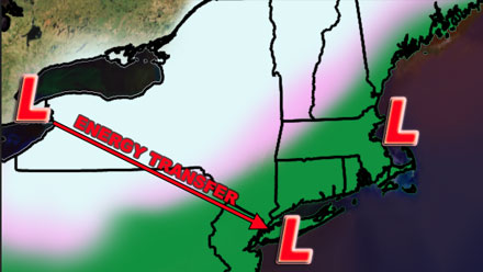
Rainy storm track continues
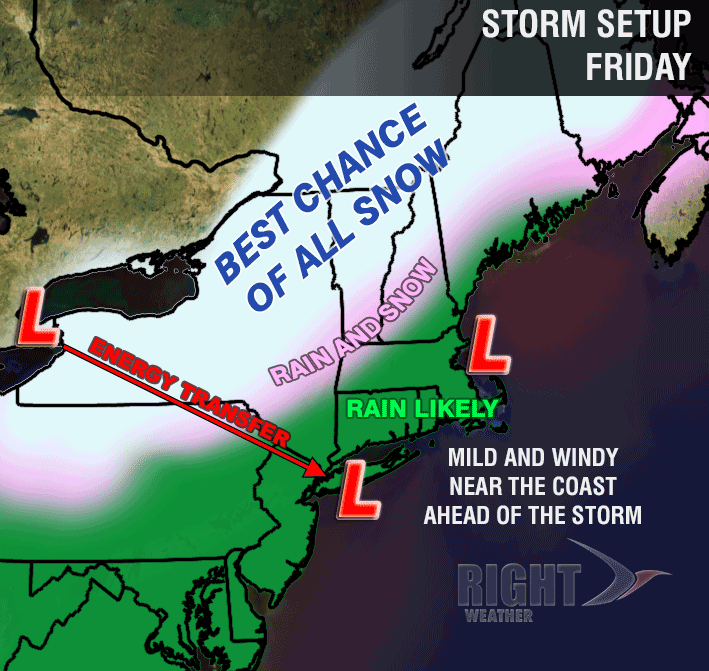
The next weather maker is also going to bring rain to Southern New England initially, with a wintry mix in Northern New England. The temperature will rise through the 40s Thursday night as the rain moves in by dawn. The wind will be 15-30 mph out of the southeast ahead of the system. Rain will continue on Friday, with the temperature most likely reaching the upper 40s to low 50s in RI, CT and SE MA. The mild air will not be staying around for long. Once the storm gets north of Southern New England, colder air will wrap in on a gusty west-northwesterly wind. Some snow showers or flurries are possible this weekend, and highs will only be in the 30s.
Right now, it looks like Christmas Eve and Day will be chilly, but mainly dry, with nothing more than a few flurries possible. As a result, Southeastern New England will probably not be seeing a white Christmas this year. The weather pattern should stay active into the new year, and there are signs that it will continue to get colder. Another storm a couple of days after Christmas favors rain, but the overall storm track is gradually shifting south and east, and, eventually SNE will see some snow if the storm track stays active through the first week of January.
[/signoff]


