
The change to snow in Eastern Massachusetts finally happened around 10 pm Saturday evening. Many areas reported a very fast coating of snow after the changeover, and that bodes well for those areas to pick up a few inches before the storm races out to sea.
 The storm’s movement to the east took the heavy snow band over W RI and pushed it east through Narragansett Bay and Eastern RI. The heaviest snow of the night was falling in E RI and SE MA shortly after 10 pm. That snow band will continue moving steadily east, and there is evidence of drier air working its way through CT into W RI. Any heavy, accumulating snow should end in RI between 11 pm and midnight. It will move out of interior SE MA by 1 am- 2 am, and off of Cape Cod by 3 am – 4 am.
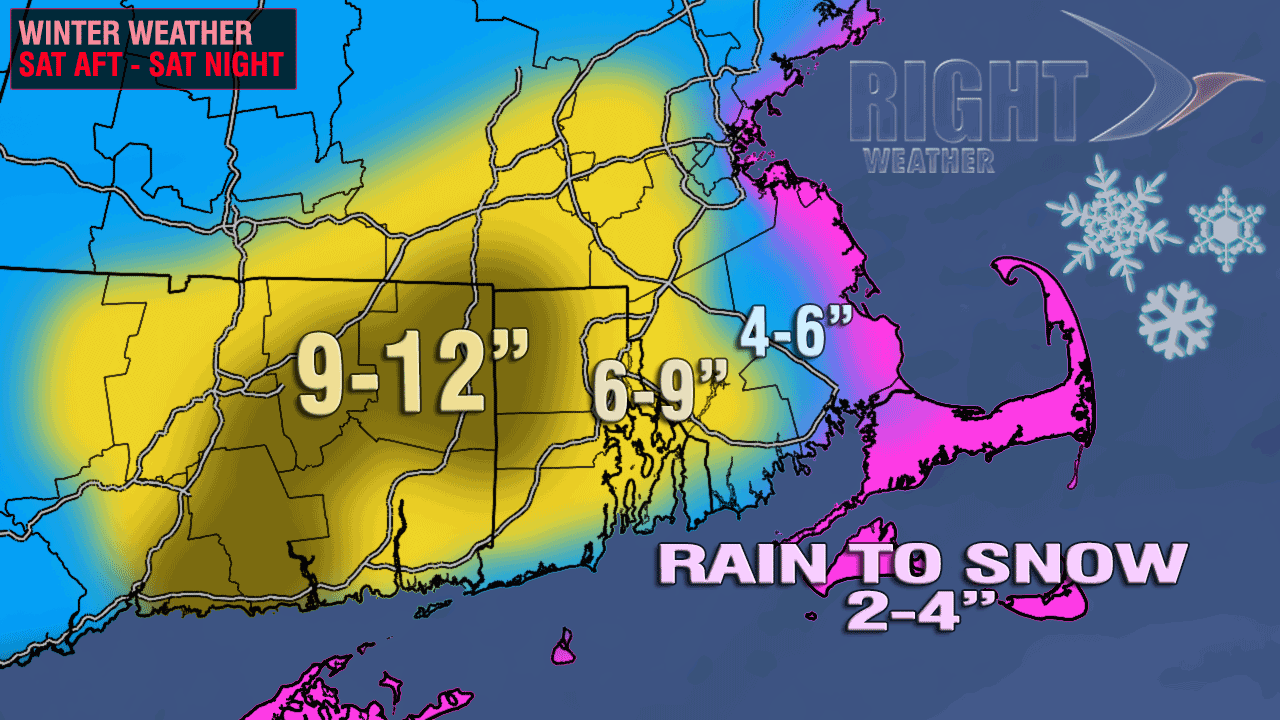
As a blizzard of snow reports come in, we are getting a better picture of what the final totals may look like. The jackpot for the storm will be in CT and W RI, with several 9-12″ reports. The I-95 corridor from just north of Westerly to about Norwood will have final totals between 6-9″. There will be lower totals at the immediate coast of RI and in parts of SE MA – particularly the Cape and the Islands.
Looking ahead to Sunday and beyond, a cold, dry stretch of weather is likely in Southern New England. The storm will not bring any snow on Sunday, but its influence will be felt with a howling wind and very cold temperatures. Highs will be in the mid to upper 20s, but the wind chills will be in the upper single digits and teens due to a 15-30 mph northwesterly breeze. It will be partly to mostly cloudy. If you’re heading to the Patriots-Dolphins game, dress appropriately, as the temperature will fall through the 20s once the sun sets.
Monday will start with temperatures in the low to mid teens, and it will only reach the upper 20s to low 30s in the afternoon as some clouds stream in from the west. Those clouds, along with a west-southwesterly breeze, will be well-timed to prevent it from being a bitter cold New Year’s Even. In fact, it won’t be very cold at all (relatively speaking) with temperatures in the mid 20s to low 30s at midnight. New Year’s Day should be partly to mostly sunny and seasonable, with the temperature in the low to mid 30s. That will be some of the warmest weather the Northeast sees all week. A series of cold surges out of Canada will bring bitter cold weather Wednesday through the end of the work week. There will be some single digit low temperatures and daytime highs may not reach 20 degrees away from the coast!


