Evening Update
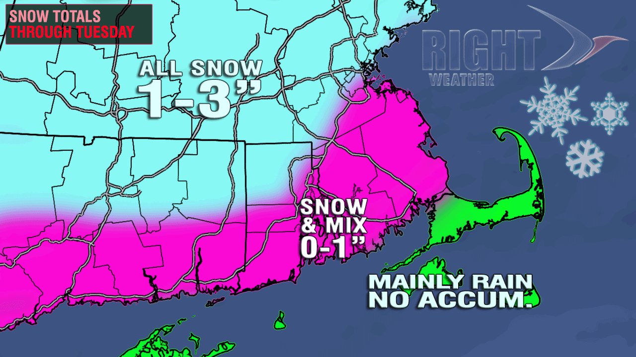
There are no big changes to the forecast for Christmas Eve or Christmas Day. Sunshine will gradually give way to clouds during the day. The temperature will rise from the 20s early in the morning to near 40 by early in the afternoon. If you’re heading out tomorrow evening, the weather should not be an issue until late in the evening or just after midnight. Some light snow will develop after 10 pm from southwest to northeast. Light snow and mixed precipitation should continue through the night into Christmas Day. Occasional light snow inland and mixed precipitation at the coast will continue into Christmas morning. Accumulations will be minor – with most areas between a dusting and 2″. The highest likelihood of seeing 2″ is in NW RI and NE CT. The travel impact should be minimal, especially if roads are treated ahead of time. The temperature is not expected to be much below freezing, even in the coldest locations. Any light precipitation should end by early Tuesday afternoon. As the temperature falls from the 30s into the 20s Tuesday night, some slick spots may develop as some wet surfaces freeze.


There will be another storm late Wednesday into Thursday. The track favors mainly rain for RI, CT, and SE MA. Away from the coast, the precipitation could begin as snow before changing to a wintry mix and then cold rain.
We’re also eyeing a third storm that may arrive in the middle of next weekend. The early, early projections shows a better chance of snow with that one.
From Earlier
Last-minute shoppers are lucking out with some very quiet weather Sunday and Monday in Southern New England. It will be partly to mostly sunny, and not too windy or cold, with temperatures reaching the low 40s both days. There continues to be some potential for some accumulating snow Christmas Eve into Christmas. A very weak disturbance will move from the Southeast to the Ohio Valley then east off the New Jersey coast Monday into Tuesday. There will not be a lot of moisture with this system, but some light snow/rain should break out in the Mid-Atlantic and New England. In some spots, it will be enough for an official (1″) white Christmas, in others a slushy coating is possible.
In Southern New England, the best chance of seeing a white Christmas is from Northern Rhode Island to Worcester County and east to Boston. The air should be cold enough to allow for all snow, and there may be just enough precipitation with the system to squeeze out an inch or two of snow. Closer to the coast, while there will likely be some snow, there will probably be some mixed precipitation and rain, too. With the precipitation expected to be fairly light, a slushy coating is the best bet in the Providence area. The accumulation map is similar to the one shown yesterday, except the snow totals have been knocked back by an inch. The areas shaded in blue will likely receive 1-2″, with an outside chance of picking up 3″ in a few spots. The pink shaded areas are likely to have some mixed precipitation or rain with the snow, and the temperature will be slightly above freezing. As a result, although the ground may be white on Christmas morning, it may not be enough for the official white Christmas designation. It looks like the precipitation will be mainly rain for the Cape/Islands.
Another storm will arrive late-Wednesday and continue into Thursday. Right now, the track of that storm looks too far west for all snow in Southeastern New England. It’s possible there could be a wintry mix at the start and end of the storm if it moves farther east than currently forecast. There will be a full update on that storm Sunday afternoon on rightweather.net.
[/signoff]


