
Snow continues to pile up as a rapidly-strengthening storm moves to the northeast in the Atlantic Ocean south of Nantucket. The storm should pass Nantucket after midnight, and be all the way to Nova Scotia by early Sunday morning. There has been a tough rain/snow battle being waged near the coast of RI and in Eastern MA this evening.
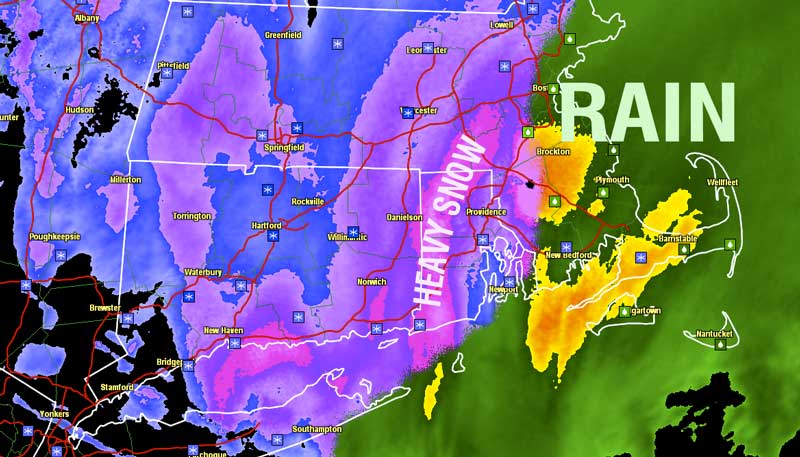
Rain has been the big winner in Eastern MA where many locations, like Boston, will likely come up well shy of their widely forecasted snow amounts. At the coast of RI, snow and rain have been flipping back and forth, but by 8pm, most had seen a change to snow, and it will stay that way for the duration of the storm.
 The duration of the storm will not be long because of the forward speed of the low pressure center. Moderate to heavy snow in RI is still on schedule to end by 10-11 pm, and it will end shortly after midnight in Eastern MA. Cape Cod may hang on to some precipitation, snow or rain, until about 3 am, but, even there, the steady precip. should be gone by dawn. The wind will increase to 35-55 mph on Nantucket and Cape Cod from late in the evening until late at night.
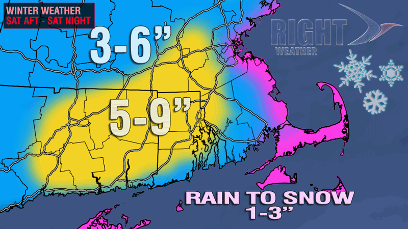
Final snow totals will be heaviest in interior CT, RI away from the immediate coast, and relatively small portion of Eastern MA that did not see a change to rain early in the evening. 3-6″ amounts are likely in many other spots including coastal RI and interior SE MA at least 10 miles from the coast. Those along the immediate E MA coast, and on Cape Cod will likely only see 1-3″ of snow because of the late change from rain to snow and the fast-moving storm.
If you’re taking the kids sledding on Sunday, be sure to bundle ’em up. It will only be in the 20s, and wind chills will be in the teens thanks to a 15-35 mph northwesterly breeze. Skies will be partly to mostly cloudy. It will be even colder in Foxboro for the early-evening Pats-Dolphins game. Tailgating temps will be in the mid to upper 20s, and it may be in the teens by late in the evening. The wind will stay active, dropping wind chills into the single digits to low teens.
There is some bone-chilling cold in the forecast for next week. Highs will be in the 20s most days, and lows will be in the single digits and teens. Thankfully, it looks like the temperature will moderate slightly Monday night to ring in the New Year.


