Many Midwest cities, including Chicago, Des Moines, and Cedar Rapids, that are normally associated with cold, snowy weather have not seen any measurable snow so far this season. Chicago just broke the record for latest measurable snow, and some of these places have not seen measurable snow for nearly 300 days dating back to last winter. This December has been remarkably mild in the Midwest, with Chicago O’Hare Airport averaging an incredible 11.5° warmer than normal. Wednesday night into Thursday, however, a storm that will signify a change in the weather pattern will end the snow drought and bring much colder weather for the remainder of the month to the Midwest.
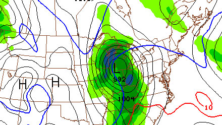
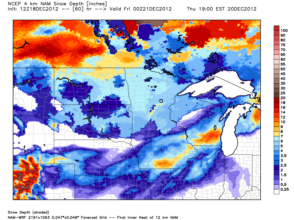
Chicago is likely to be right on the edge of the snow/rain line at the start of the storm Wednesday night. A change to snow will occur on Thursday. Of course, that could pose problems for any holiday travelers passing through the Windy City on Thursday. NW Illinois, Southern Wisconsin and Eastern Iowa will likely see all snow from the storm, and at the height of it, could experience blizzard conditions.The snow totals aren’t forecast to be off the charts, but some areas could approach a foot of snow, and many will see at least six inches.
The end of the snow drought will coincide with the start of a cold/snowy stretch for the Midwest. Another storm is likely in the middle of next week, and the long range forecast calls for colder than normal weather into the new year.
The following is a special weather statement regarding the storm from the National Weather Service office in Chicago.
...A MAJOR WINTER STORM WILL AFFECT THE MIDWEST AND GREAT LAKES
REGION WEDNESDAY NIGHT THROUGH THURSDAY NIGHT...

A RAPIDLY STRENGTHENING WINTER STORM WILL APPROACH THE AREA
WEDNESDAY NIGHT AND TRACK ACROSS NORTHEAST ILLINOIS AND NORTHWEST
INDIANA THURSDAY. RAIN IS EXPECTED TO DEVELOP AHEAD OF THIS SYSTEM
WEDNESDAY NIGHT...WITH SNOW POSSIBLE OVER FAR NORTHWEST ILLINOIS.
AS THE STORM MOVES NORTHEAST ACROSS THE AREA THURSDAY...COLDER
AIR IS EXPECTED TO CHANGE PRECIPITATION OVER TO ALL SNOW ACROSS
NORTH CENTRAL ILLINOIS BY MIDDAY...AND ACROSS NORTHEAST ILLINOIS
AND NORTHWEST INDIANA THURSDAY AFTERNOON. SNOW WILL TAPER OFF FROM
WEST TO EAST THURSDAY NIGHT.

THE HEAVIEST SNOW WILL LIKELY ACCUMULATE TO THE NORTHWEST OF THE
STORM TRACK. THIS WOULD SUGGEST THAT THE HEAVIEST SNOWFALL WOULD
OCCUR ACROSS EASTERN IOWA...NORTHWEST AND NORTH CENTRAL ILLINOIS...
AND WISCONSIN...WHERE 6 INCHES OR MORE OF SNOW IS POSSIBLE.
HOWEVER...MUCH OF THE AREA...INCLUDING CHICAGO...IS FAVORED TO SEE
SOME ACCUMULATING SNOW BY THURSDAY AFTERNOON INTO THE EVENING...
WITH CHANGES IN THE TRACK OF THE LOW PRESSURE SYSTEM HAVING A
SIGNIFICANT INFLUENCE ON OVERALL SNOWFALL AMOUNTS. A TRACK
SOUTHEAST OF CHICAGO WOULD RESULT IN MORE SNOW AREA WIDE...WHILE A
TRACK OVER OR NORTH OF CHICAGO WOULD RESULT IN MUCH LESS SNOWFALL.

WHILE THERE STILL REMAINS SOME UNCERTAINTY ON SNOWFALL DURATION
AND AMOUNTS...ONE ASPECT THAT LOOKS HIGHLY LIKELY IS THAT
NORTHWEST WINDS WILL BECOME STRONG ON THURSDAY AFTERNOON AND
EVENING WITH GUSTS AS HIGH AS 45 TO 50 MPH...POSSIBLY STRONGER.
WHERE SNOW DOES OCCUR...THESE WINDS WILL LEAD TO SIGNIFICANT
BLOWING AND DRIFTING SNOW AND SEVERELY REDUCED VISIBILITIES.

ANYONE WHO PLANS ON TRAVELING ACROSS THE MIDWEST WEDNESDAY NIGHT
THROUGH THURSDAY NIGHT SHOULD BE PREPARED FOR DIFFICULT TRAVEL...
ESPECIALLY FOR AREAS WEST AND NORTH OF CHICAGO. IT IS IMPORTANT TO
MONITOR THE LATEST FORECASTS ON THIS WINTER STORM. IN ADDITION...
THIS STORM MAY SIGNIFICANTLY IMPACT AIR TRAVEL THROUGH CHICAGO
OHARE AND CHICAGO MIDWAY AIRPORTS.


