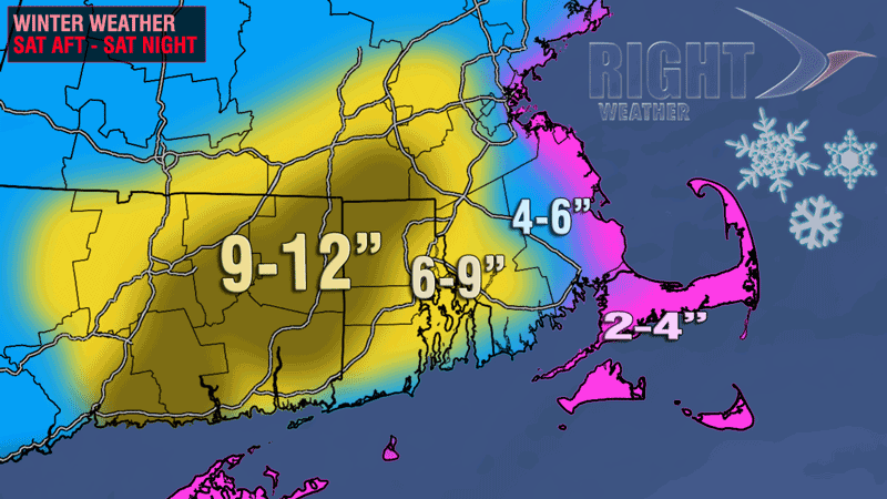
The fast and furious storm dumped more than 6″ of snow on a large portion of Southern New England, and nearly a foot on the hardest hit locations in E CT, W RI and Southern Worcester County. Officially, at TF Green Airport, the totals was 7.6″ – matching last winter’s single-day highest total. For the season TF Green has received 10.6″ of snow, about 1″ above normal. Worcester received 9.3″ of snow from the storm, and now has a 10″ surplus for the season. Hartford is also running well above normal this season after receiving 6.8″ of snow from the storm. Boston still has a snow deficit for the year because most of the storm was rain before a quick flip to snow near the end. 2.6″ fell at Logan Airport.
| Snow Totals | |||||
| City | Saturday | December | Season | Season Normal | Last Year |
| Providence | 7.6″ | 9.3″ | 10.6″ | 9.5″ | 2.3″ |
| Boston | 2.6″ | 3.4″ | 3.8″ | 9.5″ | 1.0″ |
| Harford | 6.8″ | 12.6″ | 15.5″ | 8.7″ | 12.3″ |
| Worcester | 9.3″ | 18.4″ | 26.2″ | 16.1″ | 16.3″ |
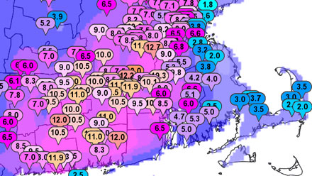
The National Weather Service has compiled a thorough list of the snowfall totals from the storm. The list can be viewed graphically on an interactive map.