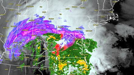
A menacing storm that brought blizzard conditions to the South Central and Midwest, and tornadoes to the Southeast is heading northeast into the Mid-Atlantic and New England. 34 tornadoes were reported Monday and Tuesday in five states from Texas to Florida. Three deaths are being blamed on the powerful storm. On the cold side of the storm, heavy snow and whiteout conditions were experienced from Arkansas to Indiana.

Cold air wedged into the interior Northeast will force the storm to redevelop near the coast. As a result, interior New England will receive significant snow. The storm track close to the coast brings mainly rain and wind to Southeastern New England. Here is the storm timeline for Southeastern New England:
- Wednesday 5-7 pm – Snow, mix, rain breaks out over E CT, RI, and SE MA. Snow likely inland, rain likely coast, mix or snow near I-95.
- Wednesday 7-11 pm – Steady precipitation. Rain/mix line steadily moves inland from the coast. By 9-10 pm any mixed precipitation in the Providence area should be changed to chilly rain. Snow/mix continues in NW RI, NE CT, and Worcester County. Snow accumulation likely, some hazardous travel in those areas. Winds increase near the coast – sustained 15-30 mph, gusts 30-45 mph
- Thursday 12 am – 7 am – Rain in CT, RI, and SE MA. Snow continues well inland at highest elevations – most likely outside of RI, CT, and all of MA except Berkshires and Northern Worcester County. Heavy snow likely in Northern New England. The rain may be heavy at times if a “dry slot” does not develop within the storm after the initial heavy burst of precipitation. Winds howl near the coast, some gusts over 45 mph likely, may see a few gusts to 60 mph at RI coast, Buzzards Bay, Cape/Islands. Chilly air hangs on in interior RI, CT, and MA. Temps in the 30s inland, and 40s near the coast. Minor coastal flooding is possible at the time of high tide: near midnight on Cape Cod, near dawn Buzzards Bay and RI coast
- Thursday 8 am – 1 pm – Rain showers continue, some drizzle and mist, Winds diminish temps in the 40s
Some colder air will wrap in behind the storm Thursday night. A few snow showers are possible as the temperature falls through the 30s into the 20s by dawn Friday. There will be a break in the action from, at least, Friday into Saturday afternoon. A storm moving through the Southeast on Saturday may slide out to sea south of Southern New England, taking the a potential accumulating snow with it. I’ll have an update to that forecast Wednesday afternoon.


