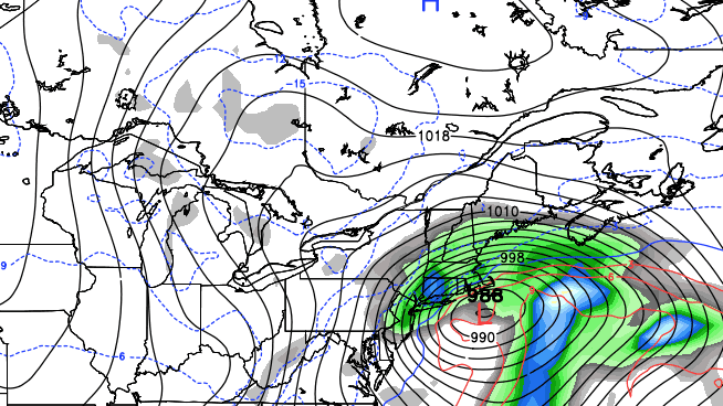
It was a wild start to winter in the Northeast with many cities receiving howling winds, heavy downpours, and unseasonably mild temperatures. The southeast wind was screaming in Southern New England, especially near the coast. As expected many places received wind gusts near 50 mph, and some were even higher. Below is a summary of the 50+ mph gusts in Southern New England.
- Conimicut Point Barrington, RI: 64 MPH Gust at 1236 PM/63 MPH gust at 1230 PM/59 MPH Gust at 1154 AM
- Marblehead Neck – Marblehead, MA: 62 MPH wind gust at 1205 PM
- Gloucester, MA: 60 MPH Gust at 141 PM
- Milton MA (Blue Hill): 59 MPH gust at 1054 AM/56 MPH gust at 1056 AM
- Buzzards Bay Entrance Tower (Elevation 100 Feet): 55 MPH gust at 1000 AM
- Fairhaven, MA (West Island): 53 MPH Gust at 1237 PM/50 MPH gust at 1011 AM
- Providence, RI: 52 MPH Gust at 1233 PM/46 MPH Gust at 1106 AM
- Barnstable, MA (Marstons Mills): 51 MPH Gust at 112 PM/50 MPH Gust at 1133 AM
- Scituate, MA (Humarock Beach): 51 MPH Gust at 1215 PM/49 MPH gust/47 MPH Gust at 1059 AM/46 MPH Gust at 1035 AM
- Fall River, MA (Borden Flats): 50 MPH Gust at 1006 AM
- Rockport, MA: 50 MPH Gust at 1225 PM/47 MPH gust at 1123 AM
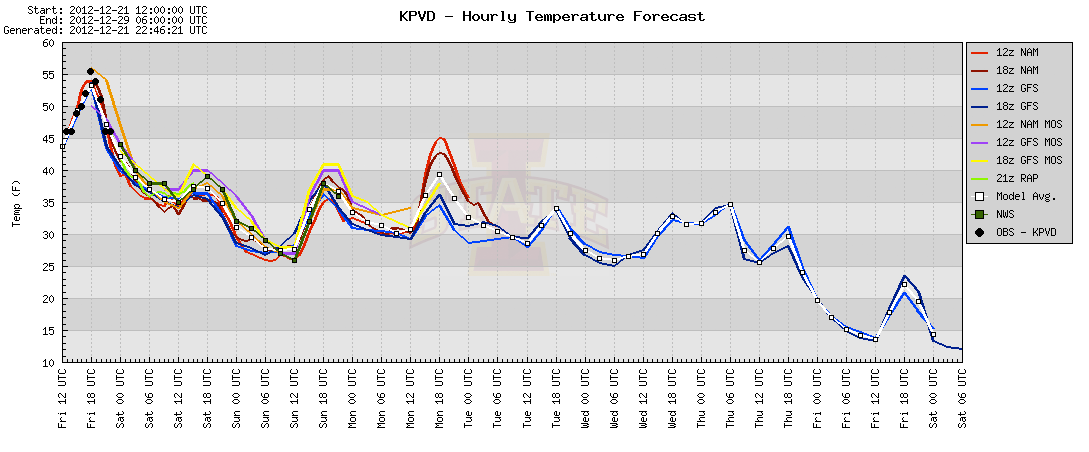
The temperature will fall into the low to mid 30s by dawn Saturday. Passing rain/snow showers are possible overnight and during the day Saturday as the broad circulation from the Midwest blizzard slowly moves east over New England. It will be mostly cloudy and brisk, with highs in the mid to upper 30s on Saturday. Sunday looks a bit brighter, but still cool, with highs again struggling to reach 40. The weather will stay quiet into Monday, and last-minute shoppers won’t have anything to worry about except for the crowds as clouds gradually increase and the temperature tops out in the mid to upper 30s again.
First storm a weak one
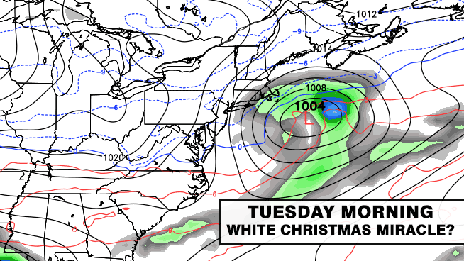
There is still hope for a white Christmas. As was outlined in the update earlier today on rightweather.net, Providence typically sees a white Christmas about one out of every three years. This year, a fast-moving system may take the perfect track to bring some light snow late Monday night into Tuesday morning. At this point, it’s too early to pinpoint the exact track of the storm, and that will be critical in determining if it’s snow, rain, or just flurries in Southern New England. Based on the current information, it does not look like this first storm of next week will be a big one. Skies should clear on Christmas day, and some chilly weather will move in behind the storm.
Second storm looks stronger
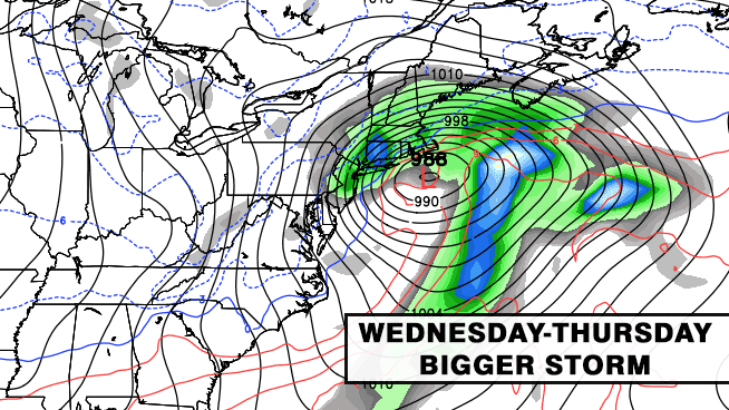
While the relatively weak Christmas morning weather system moves offshore, another, potentially much bigger, storm will be developing in the southern states. That storm will move through Southeast and Mid-Atlantic Wednesday morning, and may spread some snow/rain into New England by as soon as late-Wednesday. The storm has the potential to become a Nor’easter, with gusty winds and relatively heavy precipitation. The track is uncertain, and right now the odds of heavy, accumulating snow are higher for interior New England than for the big cities or the coast. It is still more than five days away, and a lot can change between now and then, but the odds are pretty good that New England, particularly SNE, will be dealing with a storm in the middle of next week.
Chance of a third storm next weekend
The weather that follows the midweek storm is likely to be very cold. Many computer models are projecting temperatures that may not make it out of the 20s, with lows in the teens, Friday through next weekend. The details are vague now, but the long range projections also have another weather system moving from the Southeast to the Atlantic Ocean sometime between late next weekend and just after the New Year. With a lot of very cold air in place, it could be an all-snow event for Southern New England. Keep in mind, this a 10-day forecast, and it may not come to fruition. The bottom-line is the balmy weather pattern that has dominated the country for the month of December is changing in the wake of the big storm that brought a blizzard to the Midwest, tornadoes to the South, and today’s wind/rain to Southern New England. Brace yourself, real winter is coming in the next few weeks.