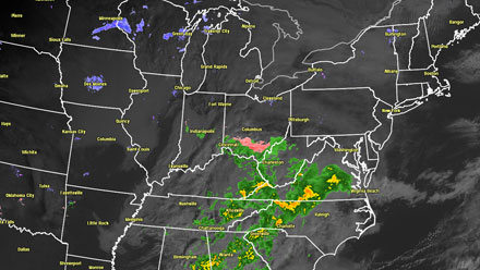
A fast-moving, weak weather system will bring some light snow, rain and mixed precipitation to Southern New England on Christmas Eve and Christmas Day. Inland, it should be as true a white Christmas as one could hope for. Go to sleep with a few flakes flying, wake up with a nice blanket of white. It is not the type of system that will cause huge travel problems, but some untreated surfaces may become slick due to the combination of light snow and light freezing rain or drizzle in some locations. Snow totals will be enough to make for a festive scene early Tuesday morning, and, there may be enough inland to shovel or even try out the new sled that Santa left under the tree. As for the new snowmobile Santa left, that may have to wait for a bigger storm!
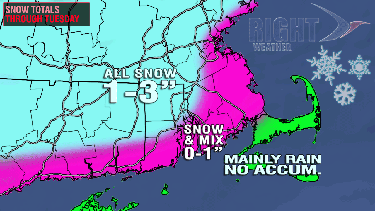
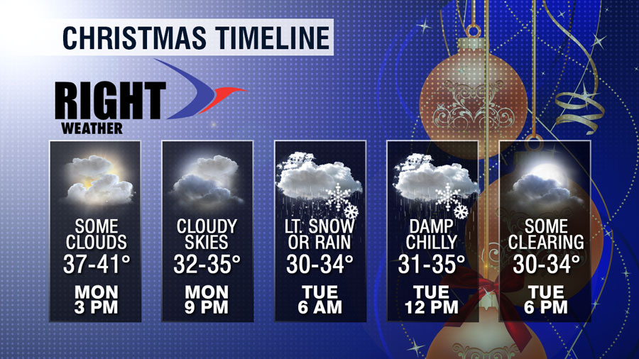
The timing of the system has not changed much. There are no weather concerns for last-minute shoppers through mid-evening Monday. Snow or a mix of rain and snow will develop between 10pm-midnight in Southern New England. Light snow, rain, or a mix continues after midnight, with the best chance of accumulating snow inland, and the best chance of rain near the coast. The wintry mix continues Christmas morning before tapering to drizzle, freezing drizzle, or flurries early in the afternoon. The final snow totals should be enough for an official white Christmas (1″ of snow) in most areas away from the coast. The best chance of picking up 2-3″ of snow is in NW RI, NE CT and southern Worcester County.

The following is from the National Weather Service:
...WINTER WEATHER ADVISORY IN EFFECT FROM 10 PM THIS EVENING TO
10 AM EST TUESDAY...

THE NATIONAL WEATHER SERVICE IN TAUNTON HAS ISSUED A WINTER
WEATHER ADVISORY FOR LIGHT ICE AND SNOW...WHICH IS IN EFFECT FROM
10 PM THIS EVENING TO 10 AM EST TUESDAY.

* LOCATIONS...NORTHERN CONNECTICUT...CENTRAL RHODE ISLAND AND THE
  SOUTHEAST COASTAL PLAIN OF MASSACHUSETTS.

* HAZARD TYPES...LIGHT ICE AND SNOW.

* ACCUMULATIONS...SNOW ACCUMULATION OF UP TO 1 TO 2 INCHES...ALONG
  WITH A TRACE TO NO MORE THAN A TENTH OF AN INCH OF ICE.

* TIMING...LATE TONIGHT INTO MID MORNING TUESDAY.

* IMPACTS...THE COMBINATION OF LIGHT SNOW AND LIGHT FREEZING RAIN
  OR DRIZZLE IN THE MORNING HOURS WILL LEAD TO SLIPPERY CONDITIONS
  ON UNTREATED ROADWAYS AND SIDEWALKS. THOSE WITH TRAVEL INTERESTS
  ARE URGED TO USE CAUTION.
High temperatures on Tuesday will be in the low to mid 30s, and the temperature will fall into the 20s Tuesday night. A bit of black ice may form on any wet surfaces as temperatures fall Tuesday evening. Be extra cautious when heading home. Another storm is likely Wednesday night into Thursday. It should be mainly rain near the coast, but some wintry weather is possible inland before a change to rain. I’ll have an update on that later Monday, but, right now, I’m being summoned to make a run to the grocery store – lucky me! [/signoff]


