The temperature at in Providence and Boston (and most of the rest of SNE) has not been above freezing for a full week dating back to late last Sunday evening. The streak should reach 180-190 hours before finally ending sometime Monday afternoon or night. It is the harshest cold snap in January since 2005, coming in colder, but a bit shorter, than a cold snap in January 2009.
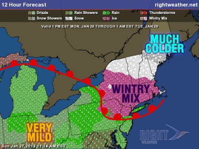
Wintry Mix Monday
Monday will begin with temperatures in the teens to low 20s. Clouds should thicken quickly Monday morning, and some snow and mixed precipitation will break out in the afternoon. It will be a wintry mix during the evening commute, and some slick roads are likely away from the coast. The snow accumulation (details here) should be relatively minor, but the frozen ground and lingering cold temperatures near the surface are cause for concern. A Winter Weather Advisory is in effect for Monday afternoon and night away from the coast.

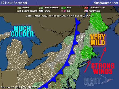
Tuesday will be cool and cloudy early. Some black ice may linger on inland roads through the Tuesday morning commute. The sky should brighten a bit Tuesday afternoon, but full sun is not expected. Highs will be in the upper 30s to low 40s. A surge of very mild weather is in the forecast for Wednesday into Thursday morning. The leading edge of that mild weather may be accompanied by a round of rain showers and some fog Tuesday night. The temperature will soar into the upper 40s to mid 50s as a cold front approaches late Wednesday.
Wet, windy, mild Wednesday night
The wind will increase out of the south, and may become strong enough to cause scattered damage near the coast Wednesday night. Some 50+ mph gusts are possible if the stronger winds aloft mix down to the surface in the heavier rain showers that will move through as the front passes Wednesday evening through early Thursday morning. Incidentally, the high temperature on Wednesday and Thursday will likely be achieved at odd times. The temperature is forecast to peak right around midnight, so Wednesday’s high comes very late in the evening, and Thursday’s high comes just after midnight. The front will be moving away from Southern New England Thursday morning. Colder air will come rushing in behind it on a gusty northwesterly wind. Thursday does not look brutally cold, but you will know the brief thaw is over as the temperature falls from the 50s very early Thursday to the 20s by midnight.


