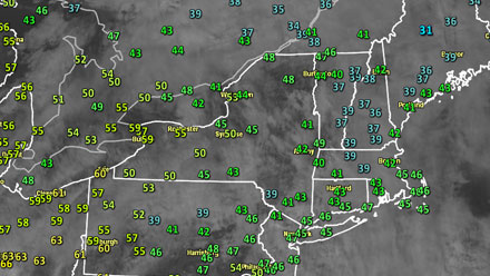
It felt more like early-spring than mid-winter in Southern New England Saturday morning. Temperatures were in the low to mid 40s, and there was some patchy mist, drizzle, and fog. The weather did not change much in the afternoon, and by early evening most places were seeing some patchy dense fog. Even though it didn’t feel like a “warm” day, it was still very mild for mid-January. By comparison, the normal high temperature is in the mid 30s this time of the year, and the normal low temperature is in the low 20s.
Sunday will be another unseasonably mild day, but it should not be as damp as Saturday. Clouds will be stubborn, and if there is any sunshine, the temperature will soar into the mid to upper 50s. Even if there is not an hour or two of sun, the high temperature should still reach 50 degrees in most places. The wind will be out of the south-southwest at 5-10 mph. Once the sun sets, damp weather will return. Once again, there should be some patchy dense fog along with drizzle and mist.
A few showers are possible on Monday as a cold front moves through. It will be very mild early in the day, but turn cooler during the afternoon and evening. Seasonable weather returns for the middle of next week. A couple of weak storms will move along a stalled front south of Southern New England. There is the chance of some flurries and snow showers Tuesday. We’ll have to watch that front to see if SNE gets swiped with a second round of showers or light snow Wednesday into Thursday.
A surge of colder weather is likely late in the week or next weekend. It is a trend that will likely continue through the end of January.


