A storm system will likely slide far enough south and be too weak to deliver substantial snow to Southern New England. The forecast totals have been lowered to a broad brushed 0-2″ for all of Southern New England, with the highest likelihood of seeing 2″ at the RI coast, Buzzards Bay, Cape Cod and islands. Before the storm brushes by, there will be more very cold weather in Southern New England.

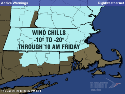
The temperature will fall from the teens Thursday evening to the single digits inland again by dawn Friday. The wind will stay active, and the wind chill will be well below zero again. -10 to -20 wind chills are possible in NW RI, interior MA, and interior CT, causing the National Weather Service to issue a Wind Chill Advisory.

Sun on Friday will give way to late-day clouds as the fast-moving weather system enters the Northeast. It will be a little more bearable, with highs in the low to mid 20s. Light snow, snow showers, or flurries are likely Friday night until about dawn Saturday as that system scoots out to sea. A reinforcing shot of cold air will move in behind the storm and stay through the weekend. It won’t be as brutal as what Southern New England is experiencing now, with highs in the upper 20s and lows in the teens – still colder than normal for late-January.
Snow/mix possible Tuesday
The temperature may finally reach 32 degrees on Monday afternoon as high pressure crests overhead then starts to slowly move offshore. At the same time, a surge of milder weather will be making it’s way through the Midwest. The initial thrust of warmer air in the Northeast may come with a round of snow and mixed precipitation on Tuesday as a warm front tries to move through. Right now, it does not look like a big deal, but, depending on the timing it could be a nuisance for the AM or PM commute. The temperature will most likely stay in the 30s on Tuesday.
Briefly mild on Wednesday
Wednesday is shaping up to be the mildest day of next week, and possibly of a two to three week span which began on January 21. The milder weather may be accompanied by a gusty southerly wind and rain showers. If the storm tracks west of the Appalachians then the high temperature may reach the low 50s near the coast. Storm tracks, as we know this Friday’s forecast, can be highly uncertain when the event is still nearly a week away. After that system passes, all indications are that another surge of cold air will enter the Upper Midwest and Northeast and stay through the end of the first weekend of February.


