The high temperature on Monday at TF Green Airport was 62°F. It reached 60 in many places as the clouds cleared by late in the morning. Colder air slowly filtered into the western half of Southern New England Monday evening. At the same time, some showers moved from the Mid-Atlantic to Southern New England. It was not cold enough for snow, but there may be a different scenario for inland locations late Tuesday night into Wednesday.
A few lingering rain showers are possible early Tuesday at the coast, and then it will become partly to mostly cloudy, with highs around 40°. Another weak weather system will move from the Mid-Atlantic to south of Nantucket by early Wednesday morning. Snow and/or rain will overspread Southern New England by late Tuesday night and continue through Wednesday morning before tapering off during the afternoon.
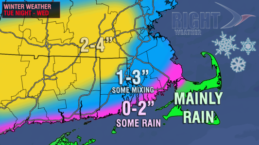
Based on the track of the storm and the limited availability of very cold air, the odds favor a mix of rain and snow from the coast to the I-95 corridor of RI, CT, and MA. Inland locations stand a better chance of remaining all snow, and a minor-moderate accumulation is possible. There are two scenarios that could play out with this relatively minor weather system.
- The storm passes close enough to the coast to allow for some milder weather to move in and change any snow to a wintry mix or rain from the coast to I-95. If this occurs, the final totals will be less than an inch from the coast to the cities in the I-95 corridor, including Providence and Boston. Farther inland, NW of I-295 in RI, and west of I-495 in MA, and all points north of the MA Pike will pick up about 2-4″ of snow.
- The storm stays just far enough south that enough cold air hangs on for an all-snow event inland and mainly snow near the coast, but not including Cape Cod and the islands where it will likely be mainly or all rain for the storm regardless of the track. In this scenario, a general 2-3″ snowfall is likely in most spots, with an inch or so at the immediate coast.

There are really subtle differences between the two scenarios because the storm does not have much potential to begin with. On the high end some spots get 3-4″ if one of the snowiest scenarios play out. The bottom line is if the storm tracks too close to the coast it will be a mainly rain event for all areas shaded in pink or blue on the accumulation map. The steadiest precipitation is likely from late Tuesday night through midday Wednesday. As a result, the Wednesday morning commute could be impacted. It’s quite possible that the precipitation will start as snow near the coast before transitioning to rain by mid to late morning.


