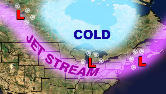
Cold weather will come rushing back into the Northeast after a brief windy and wet warm-up on Wednesday. Along with cold may come several close calls with accumulating snow in Southern New England late this week into the middle of next week. Three fast-moving weather systems will move from Western Canada to the Atlantic Ocean in a five day stretch. These “Alberta Clippers” are generally not huge snow producers, but if conditions are right they can bring several inches of snow along their path through the Upper Midwest to the Great Lakes and Ohio Valley then to the Mid-Atlantic and New England. They are called clippers because they move swiftly like the clipper sailing ships of the 19th century. The systems originate in the Pacific Ocean, but reform after coming through the mountains of British Columbia and then Alberta – hence the first part of their name.

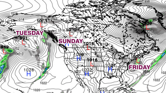
The first clipper is possible on Friday. At this point, it looks like it will redevelop over the Atlantic Ocean a bit too late to bring anything more than snow showers to the coast early in the day. Because it will not be particularly strong, the point of redevelopment is key with this system. There could be steady snow if it develops farther south and closer to the coast than the current projections.
Most computer models agree that a second clipper will arrive late in the weekend. That one should have a bit more energy and moisture than the one that passes on Friday. The track of the system is still in question, and where the center passes between Quebec and south of Southern New England will also determine where the steadiest snow falls. A track farther south would be more favorable for accumulating snow in Southern New England. At this point, Sunday looks like the safest bet for some snowflakes to be flying in Southern New England. Right now, it doesn’t look like more than a 1-4″ event.
Another clipper may follow on the heels of the Sunday system bringing the chance of snow again by Tuesday. There are some computer models that intensify that system into a stronger storm capable of about a half foot of snow, but others are much weaker and farther north, bringing nothing more than some snow showers or flurries. To put the forecasting difficulty in perspective, this weather system will still be in the Gulf of Alaska when the first clipper is scooting by on Friday morning.

The bottom line is there will be several shots at snow between Friday and Tuesday, but it is still unclear if they’ll near-misses that bring just a few flakes and minor accumulation or if any of them will take a sweet spot track that allows for a widespread plowable snow. We’ll keep you updated as the week progresses.


