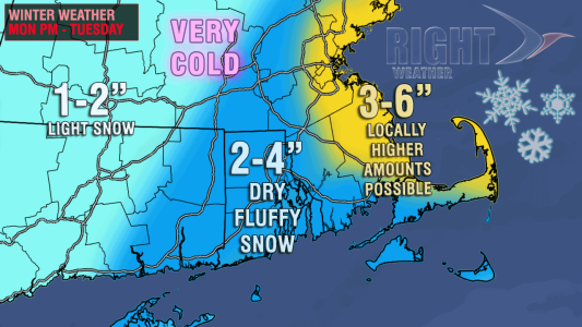
A small storm will deliver a decent burst of snow in Southeastern New England Monday night. The storm will develop just southeast of Nantucket, and snow is likely to overspread RI and SE MA near sunset. The steadiest snow in RI, eastern CT, and interior SE MA will occur before 1 am, with the snow tapering to snow showers and flurries between 1 am and dawn. In far Eastern MA, steady snow may continue through dawn.

The snow is likely to be dry and fluffy because of very cold air aloft. The temperature inland will be in the low to mid 20s while the snow falls. It will be in the upper 20s near the coast. While not a major storm, the snow is likely to be a nuisance for anyone travelling Monday evening or very early Tuesday morning.

Tuesday looks mostly cloudy with some lingering flurries and snow showers in RI and interior SE MA. Steadier snow is possible through the morning at the Eastern Massachusetts coast, but it is very difficult to pinpoint exactly where it will occur. Anywhere from the North Shore to Cape Cod could be the focal point for another few inches of snow Tuesday morning. It will be bitter cold on Tuesday, with highs in the low to mid 20s. A fresh north-northwest breeze will have wind chills in the single digits to low teens.
Frigid weather in the midweek

Low temperatures Tuesday night will be in the single digits to low teens with fresh snowpack and mainly clear skies. There should still be a light breeze, so wind chill at or below zero are possible. Wednesday looks brutally cold. Highs will only be in the teens – even with a decent amount of sun. It could be the coldest day in two years in Southern New England. The breeze will be active again, and that will keep the wind chills within a few degrees (either side) of zero all day. The coldest night of the workweek may be Wednesday night, with temperatures dropping to near 0 in the northern half of RI if the wind relaxes under clear skies. The temperature will be well below zero in most of Northern New England. Lows at the coast on Wednesday night will be in the single digits. Check page two for the early outlook on another snow event later in the week.


