
Cold rain showers moving through Southern New England Friday night will linger into early Saturday. Clouds will be very stubborn on Saturday, and some mist is possible, especially in the morning. The temperature will slowly and steadily climb into the low to mid 40s, but it will not feel that warm because of the clouds and high relative humidity.
It will stay cloudy, damp, and relatively mild Saturday night. Some patchy mist, drizzle, and fog is likely. Lows will be in the mid to upper 30s inland, and upper 30s to low 40s near the coast. The clouds should thin and lift enough to eliminate any mist/drizzle by midday Sunday. The weather looks good for the Pats-Texans at Gillette Stadium.
It’s possible the sun will break through from late-morning into the afternoon. If the sun shines, highs will be in the mid to upper 50s. If there is limited sunshine, which is more likely, than highs will be in the low to mid 50s. The wind will be out of the south-southwest at 5-10 mph. Low clouds and some mist/drizzle may return by mid to late Sunday evening. It will be very mild Sunday night, with the temperature falling into the low to mid 40s.
The temperature will peak sometime Monday morning or early afternoon in the 50s before a cold front moves through. Some passing showers are possible early Monday, but it should get drier as the day progresses. The temperature will tumble after the cold front gets offshore. It will be seasonable Tuesday through Thursday, with the chance of some light snow, rain, or mixed precipitation on Tuesday. Right now, Wednesday and Thursday look dry. Highs will be in the mid 30s to low 40s. Lows will be in the 20s.
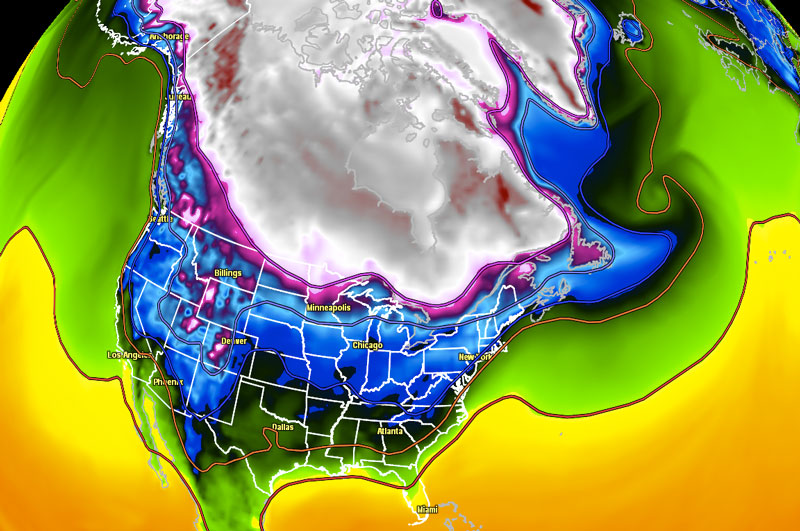
An Arctic cold front will move through late next week. At this point, the timing of the front is in question, but it looks like it will happen between Thursday night and Saturday. A shot of bitter cold weather is possible, and, if the full brunt of the cold air hits, highs may not make it out of the teens either Friday or Saturday.
Overall, it looks like a much colder and more active weather pattern from the middle of next week through the following week. There are some signs that an even colder shot of Arctic air will arrive in about 10 days. Reports of winter’s demise have been greatly exaggerated!


