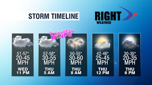
A vicious storm system responsible for several tornadoes and at least two fatalities in the South is moving east to the Eastern Seaboard late Wednesday night into Thursday morning. Record breaking warm temperatures have been seen from the Midwest to the Northeast in advance of the storm, and it will stay very mild in Southern New England until the cold front passes by mid-morning Thursday.
The main threat from the storm is for strong, damaging wind gusts in Southern New England. A High Wind Warning is in effect for the potential of 60 mph wind gusts. Some computer models are indicating even higher gusts, but the cool ocean may be enough to stabilize the atmosphere just enough that the strongest winds do not mix down to the surface. Winds will be hurricane force less than 1000 ft off the ground early Thursday morning.
If you’re traveling over area bridges tomorrow morning, hang on tight! It would not shock us if the Pell Bridge in Newport was closed, at least to high profile vehicles, for a short time during the peak wind gusts which are projected to arrive between 5 am – 7 am. Showers will become heavier late tonight, and some thunderstorms are possible just ahead of the cold front. It’s safe to say that the Thursday morning commute will be impacted by the weather. The worst of the wind/rain is expected smack dab in the middle of the commute between 5 am – 8 am. It will stay very mild through the end of the rain showers, then gradually turn colder as skies clear during the day.
The strongest winds will be out of the south-southwest before the front passes. After it moves through, the wind will shift and come out of the west. A howling wind is likely in the afternoon, but it should not be enough to cause damage. With no foliage on the trees the threat of power outages is not as high as it is at other times of the year. Winds to 60 mph, however, are capable of downing branches, trees, and power lines, so some outages are possible. Be sure to put your phone, tablet, etc. on the charger tonight!
In addition, minor coastal flooding is also possible at the time of high tide. Large waves crashing onshore will also lead to minor beach erosion. There will likely not be enough rain to lead to flooding in RI or SE MA, but W MA and W CT could see some street flooding late tonight and early tomorrow.


