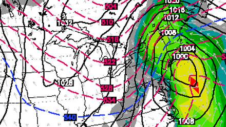
Another near-miss storm moved just east of New England Sunday evening and headed for Nova Scotia. Snow showers and flurries continued primarily in Eastern MA, but will not amount to much by Monday morning. The temperature will fall into the teens to low 20s by dawn Monday.
As the storm intensifies over the Canadian Maritimes on Monday, the wind will increase out of the west-northwest in New England. There should be a 15-30 mph breeze under partly to mostly sunny skies. It will be another chilly day, with highs in the low 30s.
A weak system will move south of Southern New England early Tuesday. Some snow showers or flurries are possible near the coast. The afternoon will be partly cloudy with highs in the low 30s. Another Alberta Clipper will head for the Atlantic Ocean on Wednesday. It’s not likely to bring steady snow to Southern New England, but some snow showers and flurries are possible again. Highs will be in the 30s on Wednesday.
Storm possible Friday
Dry and cool weather is in the forecast for Thursday. Highs should be in the low to mid 30s. The weather action may pick up late in the week. A pair of storm systems approaching the East Coast on Friday may phase into one stronger system capable of producing significant snow to the north and west of the storm’s center.
Right now, there are a lot of uncertainties with the late-week forecast, including the track and intensity of the system. There is a possibility that the two branches of the jet stream will not phase, and a much weaker system would move through the Northeast if that occurs. Even if phasing does occur, the exact track of the storm will be critical in determining what type of precipitation falls in Southern New England. A track too close to the coast would bring a mix of snow and rain to RI and SE MA.


