Sunday was a great day for shoveling, sledding, and, most of all restoring power after the blizzard that dumped up to 40 inches of snow in Southern New England early in the weekend. Thousands of Southern New Englanders saw their lights flip back on as crews worked to get the electricity back to the hundreds of thousands who lost power during the blizzard. While many were happy to have power and heat restored, as of Sunday evening there were still tens of thousands in RI, and more than 150,000 in MA without power. Sunday night won’t be quite as cold as Saturday night was, but it will still be chilly with the temperature dropping into the teens to low 20s by late in the evening, then rising a bit during the remainder of the night.
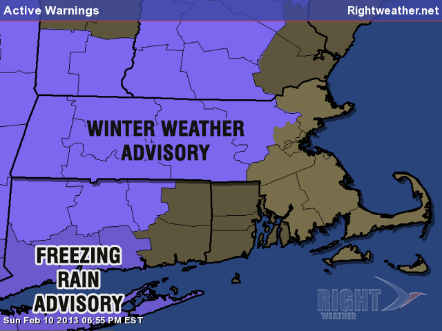
FREEZING RAIN ADVISORY FROM 3AM-9AM MONDAY
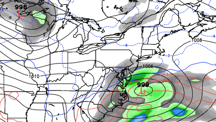
There is another weather system in the forecast, but, rather than bringing snow, it will bring a wintry mix to rain inland, and nothing but rain near the coast. There may be enough cold air around inland at the start of the storm for a period of snow, sleet, and freezing rain. A Winter Weather Advisory and Freezing Rain Advisory is in effect for parts of MA, CT and NY in the areas that could see the wintry mix prior to a change to chilly rain.
A southeasterly breeze will help to get the temperature above freezing before the precipitation arrives near the coast, and it should be rain from start to finish from the coast to the I-95 corridor. Thankfully, it will not be a huge soaking rain storm, but about a half inch of rain soaked into the snowpack could compromise some weakened roof structures. Also, some bigger than normal puddles are possible due to snow/ice clogged or blocked storm drains. The temperature will rise into the mid to upper 30s inland, and low to mid 40s near the coast.
The weather looks fairly quiet in the midweek. It will be partly to mostly sunny and seasonable on Tuesday. Highs will be near 40 (the normal high right now) and lows will be in the 20s. Wednesday looks dry and a bit cooler, with highs in the 30s. A developing storm over the Southeast will move into the Atlantic Ocean spreading some snow into the Mid-Atlantic states. Right now, it looks like that storm will narrowly miss Southern New England, but there are still a few days to go, and a track a bit farther north than currently projected would bring accumulating snow.
The active weather pattern will continue late in the week, with another possible storm. It’s very early in the game, but that storm could bring steadier precipitation, and if the track is south of Southern New England, it would mean more snow – about the last thing some Southern New Englanders want to see!


