Noon Update: Accumulating snow has ended in RI. It will be mostly cloudy, windy, and very cold this afternoon. Some late-day clearing is possible, but the temperature will not make it above the mid 20s before falling through teens tonight. The wind will stay active, keeping wind chills not too far from zero. Snow will gradually end from west to east in Eastern MA this afternoon. Final totals should be similar to what you see in the Right Weather accumulation map below. Most of RI will pick up about 3-4″, with closer to 6″ in interior SE MA, and a bit above 6″ in far E MA.
9AM Update: Snow was tapering to flurries in W RI around 9am. Steady, light snow will continue in E RI through most of the morning. Heavy snow was falling along the MA coast, and moderate to heavy snow is likely in SE MA until early in the afternoon before tapering off during the mid to late afternoon. The wind will continue to howl, and it will stay very cold through this afternoon. Bundle up and take it slow!
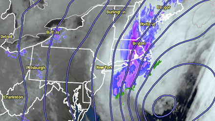
A fast-developing ocean storm was pounding Southern New England late Saturday night into Sunday morning. After light, occasional snow all day Saturday through Saturday evening, the snow intensified late Saturday night, and the temperature plummeted from the low 30s to the low 20s. A wind-whipped snow was falling in all of RI and SE MA at dawn on Sunday.
 Several inches of new snow is likely in E CT, RI, and SE MA through midday Sunday as the storm continues to strengthen quickly over the Gulf Stream off the Atlantic Seaboard. The wind is out of the north-northwest, and will gust to more than 55 mph on Cape Cod and the islands, and to nearly 50 mph in RI and interior SE MA. The combination of the moderate to heavy snow bands and strong winds will bring near-blizzard conditions for a time Sunday morning. The best chance of seeing prolonged blizzard conditions is on Cape Cod and Nantucket late in the morning.
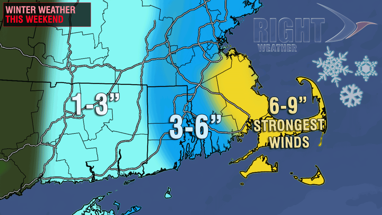
The updated accumulation map has widespread 4-6″ amount in E RI and interior SE MA, with the potential for a few more inches as the storm lasts well into the afternoon in far E MA. The snow will be tough to accurately measure because it is so dry, fluffy and being blown around.
The temperature will not budge much on Sunday. It will be in the upper teens to low 20s Sunday afternoon, and the wind will continue to howl. That will drop wind chills to 0-10 degrees throughout the day.
Skies will clear Sunday night, and the temperature will fall into the single digits to low teens. The wind will stay active (15-30 mph), and that will drop wind chills to near or below zero in all of Southern New England. Monday will be dry, brisk, and cold, with highs in the mid 20s to low 30s.


