When a storm like the one that is projected to arrive on Friday is in the forecast, there are a lot of reasons for concern including school cancellations, road safety, power outages, wind damage, etc. As meteorologists, we have another big concern – what if the forecast is a bust? In a situation like this, with so much attention being paid to the forecast, a prediction that goes awry will further perpetuate the myth that we’re wrong all the time. While it is highly unlikely that the storm fails to develop on Friday into Saturday, there are still some scenarios on the table that would make the current forecast not look so great.
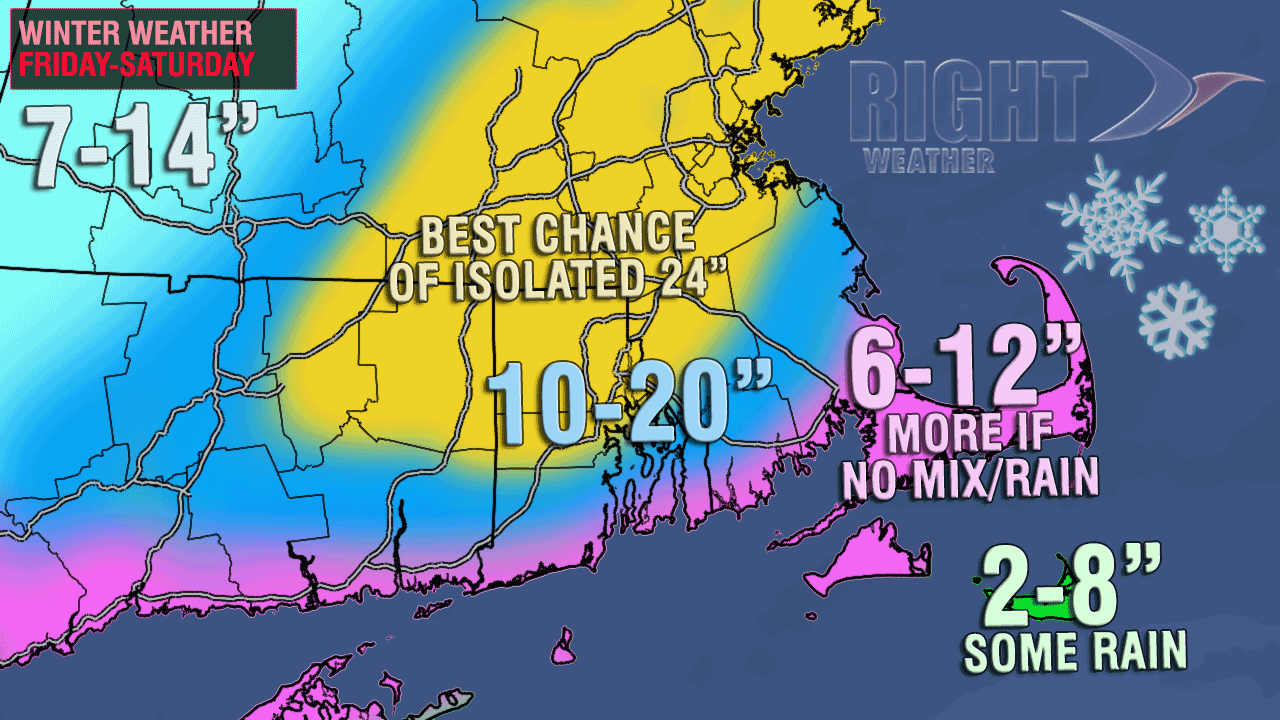
At Right Weather, our chief concern is that the storm may track so close to the coast that it bring a lot of rain from the coast to Providence, and does not produce the currently forecasted snow totals. If the storm tracks southeast of Nantucket as currently projected, then most of RI and interior SE MA should have no trouble seeing at least a foot of snow, and maybe more. If the storm tracks too close to the coast, all those high snow totals will be pushed farther inland into, at least Northern RI, if not Central MA and Northern New England. There would still be some snow as the storm moved away, but the amounts would be less than the currently projected 10″ minimum for the I-95 corridor.

So, what are the odds of this happening? I can’t put a scientific number on it, but my gut feeling is that there is about a 25-35% chance that this storm will travel much farther north than currently forecast. Of course, on the flip side, that means there’s a good chance that our current forecast will be decent. We could split the difference between the two scenarios with our snow forecast, but that is not likely to yield an accurate result. With this storm, it’s not all nothing, but it’s all or not nearly as much. Basically, in our opinion, the Providence area is either going to get 10-20″ as currently projected or 4-7″ if the storm tracks farther north than forecast. So, a 7-14″ doesn’t really work because we don’t think there’s a great chance that Providence winds up with an 7-10″ storm.
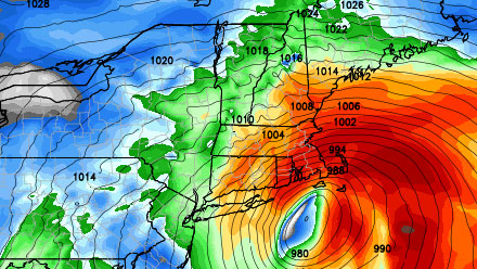
That is far and away our chief concern – a storm that tracks too close and brings in too much mild air. Another lesser concern, especially given the beefy snow forecast, is that the storm reaches the huge potential some of the computer models are showing. If that occurs, then this would be one for the record books – maybe even #1 all-time. Wouldn’t that be something? Breaking the 35 year old record of the Blizzard of ’78 just two days after the anniversary.
While there are other scenarios in play, we can only give one forecast, and that’s for a widespread 10-20″ snowfall with a few places a few inches higher, and a few spots a few inches lower.