Cold northwesterly winds were gusting early Wednesday morning in the wake of a cold front that brought 0.4-0.75″ of rain to Southern New England Tuesday night. It will be partly to mostly cloudy, blustery, and chilly Wednesday afternoon. Highs will be in the mid 30s, but it will feel colder because of the 15-35 mph wind. Wednesday night will become clear, and the wind will not be quite as gusty, but there will still be a noticeable wind chill as the temperature falls into the low 20s by early Thursday morning.
Thursday looks bright and chilly. There will still be a 10-20 mph breeze, and high temperatures will only be in the low 30s – about 10 degrees below normal for late-February. Friday will be a fairly quiet, seasonable day. It will be partly to mostly sunny, and a bit milder, with highs near 40.
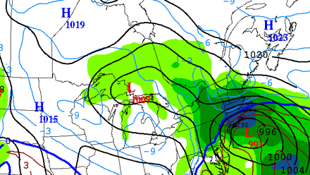
Big storm in the Plains
While the weather is quiet and chilly in the Northeast, a storm will be plowing through the Plains bringing more than a foot of snow of the winter to parts of Nebraska, Kansas and Missouri Wednesday into Thursday. Farther south, over the Southern Plains and lower Mississippi Valley, there is the threat of freezing rain. The southernmost states could see some severe weather as the storm moves through on Thursday.
Weekend storm chances increasing
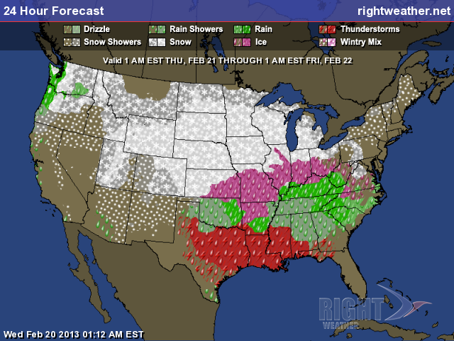
That storm is the one people in the Northeast should be watching as the weekend approaches. The odds of it having an impact in the Northeast are increasing, but there are many details of the forecast that are still uncertain. Right now, it looks like the storm may come close enough to Southern New England to bring a mix or rain late Saturday into Sunday. The track of the storm will be critical because it can mean the difference between cold rain and temperatures in the mid to upper 30s, and another snowfall that exceeds 6″ in the hardest hit areas. At this point, the highest likelihood of seeing another 6″+ snowfall is in interior New England from the MA Pike north. Click here to see the latest computer model trends analysis of the weekend storm.


