The Blizzard Watch has been expanded, and it may be upgraded to a warning later today. The two systems that will merge into a monster storm are moving through the Midwest and Southeast on their way to a meeting off the Carolina coast early Friday. It is a lock that there will be a major Northeast snowstorm, but there are still some uncertainties about who will get hit the hardest. Here is what the Thursday morning computer models are indicating.
A few things:
12Z run = 7 am EST initialization time
00Z run = 7 pm EST initialization time
QPF = Quantitative Precipitation Forecast (how much liquid precipitation falls – must convert for snow totals)
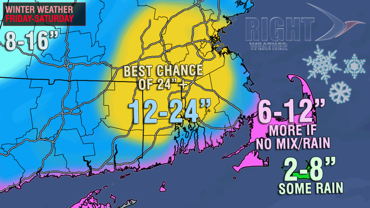
Here is the current Right Weather accumulation map
12Z ECMWF
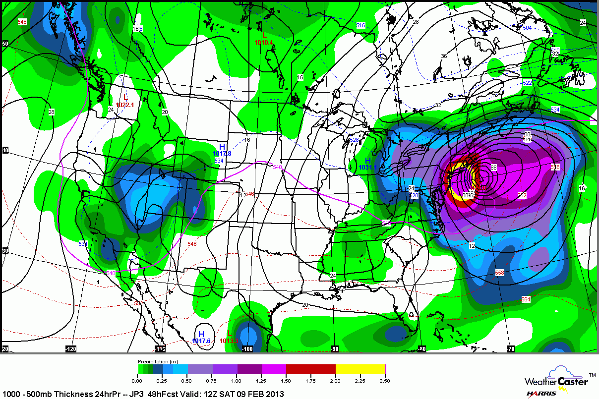
The ECMWF model comes in later than the other models. It’s kind of like saving the best for last. This model has been on to this storm for days, and it is still very solid. The track is a bit farther west when it is south of Long Island than prior runs, but it still takes a sharp enough turn to the east to keep it all snow in most of Southern New England. Total QPF in Providence is 2.6″ and it is all snow, sothat would yield about 2 feet! The wind is a huge issue for the coast. The storm lasts until mid-afternoon Saturday. There’s not much else to say about it that hasn’t already been said!
One thing about the ECMWF to keep an eye on is the fact that it’s all snow for all of SNE besides Nantucket. It would be very rare to get two feet of snow in Providence and not have it rain on the Cape/Islands. It rained there in the Blizzard of 1978, and that’s the only storm that produced more than two feet in Providence since 1905. Obviously, some significant changes to the Right Weather map on the Cape/Islands and immediate coast would be in order if it looks like the Euro will pan out.

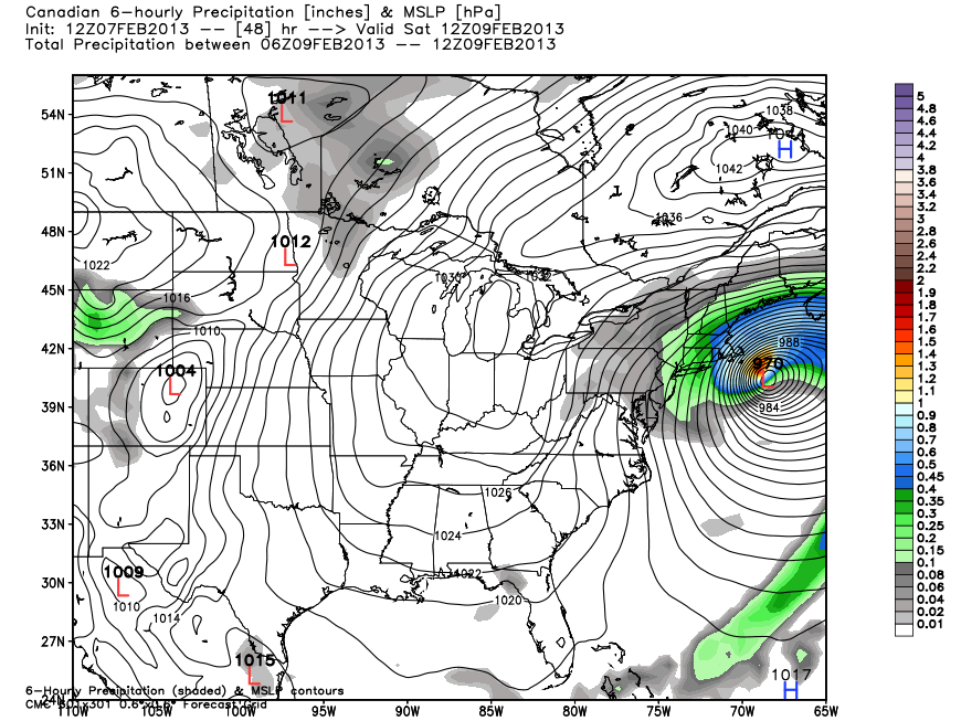
12Z Canadian and JMA (Japan)
Neither of these models are ones that we rely heavily on, but they’re both showing a monster storm for Southern New England. The JMA is an instant classic with a powerful storm over the 70/40 benchmark and 2″ of QPF over SNE. The Canadian is not far from that, with even more QPF. From what I can tell the Canadian peak snow area lines up very well with the Right Weather forecast.
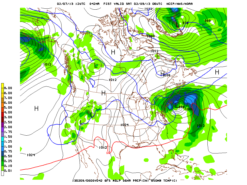
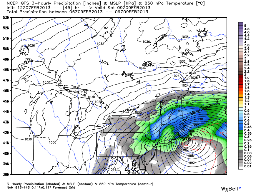
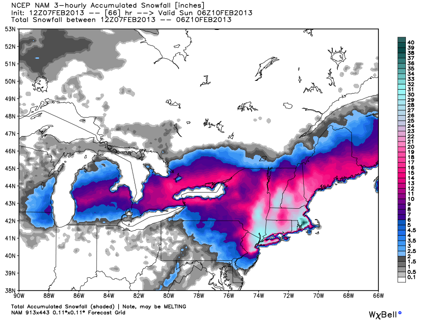
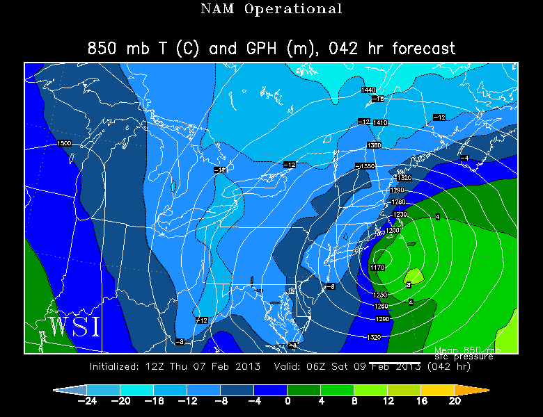
12Z NAM
Yesterday’s 12Z NAM run was one for the ages. It predicted 40-60″ of snow in RI and SE MA. Today’s run is different. The track of the storm is much closer to NYC and SNE, and that has big implications for New York City and parts of New England. If the storm tracks as close as the NAM is saying, then the Cape and Islands, and possibly the coast of RI and Buzzards Bay, will have a prolonged span of rain or mixed precipitation. What makes this run so intriguing, though, is that even with a tight track, there is a very narrow (in distance) temperature gradient between the mild and cold air. Somehow, the model says that the cold air will hang on in the Providence area, and it is predicting a whopping 24-36+” of snow for most of RI and SE MA. On the Cape/Islands, however, it has less than 10″ across the board, with most of that coming as the storm departs on Saturday. Total QPF for the 12Z NAM in Providence is 3.3″ in Providence.
It keeps the storm spinning near Nantucket for a good chunk of Saturday. By then, the heaviest bands of snow would have moved into Northern New England, and a wind-whipped moderate snow bands would be pinwheeling through Southeastern New England. Also, based on the NAM forecast of a tighter track, the strongest winds may occur at the RI coast instead of in SE MA. Either way, the entire SNE coast would see gusts over 60 mph.
This jog to the north and west is something that I’ve been concerned about occurring with this system. If correct, it drastically changes some outlet’s (not Right Weather) snow forecast for the Cape/Islands and maybe even the coast of RI and Buzzards Bay. Given the possibility that this model is correct, we are sticking with our forecast above. Another concern with this model run is that a dry slot will move through RI and SE MA at the point that should be the height of the storm. The layer of dry air wrapping into the storm has killed many a snow forecast in Southeastern New England. The heavier bands would shift into N MA and Northern New England. It’s just one run from one model, and it does not significantly change the Right Weather forecast.
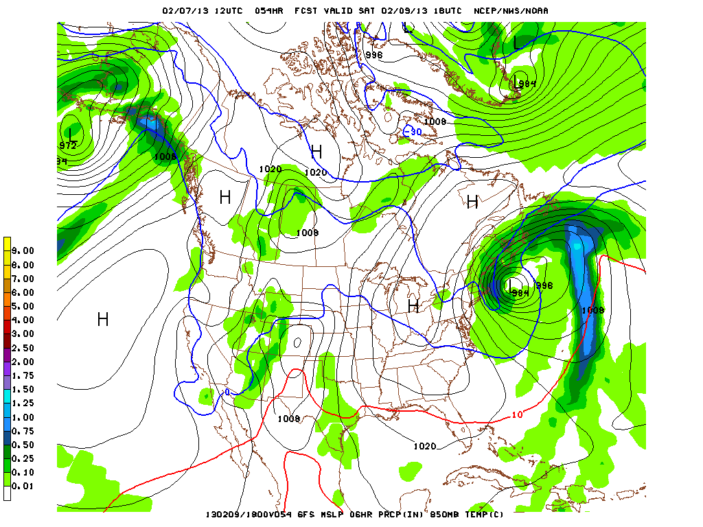
12Z GFS
Last night the 12Z GFS took a little hiatus from a monster storm scenario with a less intense faster-moving system that still brought about 8-16″ of snow to SNE. This morning’s run, although not back to the level of the NAM or ECMWF, is not as weak and fast, and give SNE a sizable Nor’easter with a high likelihood of blizzard conditions. It would most likely not be a historic top-10 kind of storm, but it would be a biggie. Snow forecasts from the GFS are for about 12-18″ of snow in all of RI and SE MA. The total QPF for Providence is 1.65″ – which would yield about 15″. A big storm, but probably not a paralyzing one. The storm is a little more progressive than the other models, with the heavy snow ending in RI Saturday morning.
One thing that the 12Z GFS eliminates is the potential for any mixing or rain – even on Cape Cod. The track is far enough offshore that it would be all snow across the board. The graphic below shows nothing for Cape Cod, but that’s because of the way the grid point are set up in the model.