Friday should be a relatively nice day in Southern New England, with plenty of sunshine and highs in the upper 30s to low 40s. The wind will be noticeably lighter than the last couple of days, and it will feel quite a bit milder without the wind chill that has made it feel colder for the past two days. Clouds will gradually increase Friday night, and the weather is of no concern for anyone heading out for a night on the town.
A storm will develop over the Southeastern United States tomorrow night, and it will begin heading northeast reaching Southern New England in the middle of the weekend. Clouds will thicken on Saturday, with some snow and rain breaking out late in the afternoon. Highs will be in the mid 30s. There will be a quick change to sleet and rain right near the coast, but a few hours of snow are possible inland into Saturday evening. Some accumulation is likely.
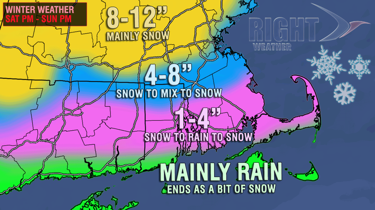
By late Saturday evening, enough mild air should arrive to change snow to mixed precipitation or rain in most of RI, SE MA and coastal CT. Farther inland, towards the MA Pike, it will be a battle between snow and mixed precipitation, and the areas that stay all snow will have significant accumulations by dawn Sunday. The rain and mixed precipitation will be heavy at times Saturday night, with temperatures in the mid to upper 30s in the areas that see a change from snow to mixed precipitation or rain. The wind will become gusty out of the east-northeast – especially near the coast.
As the storm passes Southern New England, colder air will move in behind it, and that may change mixed precipitation or rain to snow by early to mid-morning Sunday. Some accumulating snow is possible after the changeover, but most places that go from rain to snow will not see more than 1-3″ additional snow through midday Sunday when the snow tapers to flurries.
As you can see from the accumulation map, there is a short distance between areas that pick up 4″ of snow and those that may see 10″ or more. The track of the storm is critical, and it will be a very thin line between cold rain and heavy, wet snow. As a result, this accumulation map could change considerably in the next couple of days as we fine-tune the forecast. Some areas in the pink shading may pick up 2-3″ at the start of the storm, only to see some of it washed away by sleet and rain Saturday night, then coated with another 1-2″ on Sunday morning.

Snow will wind down on Sunday, and chilly weather moves in for the start of next week. The early outlook for the end of February and start of March calls for more stormy weather in the Northeast. Providence is 7″ of snow from the record for the month of February. There is an outside chance of breaking that record given the active pattern ahead for the next week.


