It’s been a “no rest for the weary” month at Right Weather, and we couldn’t be happier. If you love forecasting wild weather, then February has been your kind of month. Unfortunately, this pattern of weekend storm is undoubtedly taking its toll on area businesses that rely on lots of weekend revenue. Of course, there is another storm in the forecast for this weekend, and all the details on that forecast are available in the bunches of updates we’ve been providing.
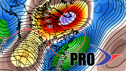
Looking ahead to next week, a very negative NAO (North Atlantic Oscillation) means a blocky jet stream and the potential for a storm to get stuck near the Eastern Seaboard. At the very least, there should be a midweek storm to deal with. In a worst-case scenario, that midweek storm connects with a late-week storm to form a long duration event that lasts into the first few days of March. The bottom line is there is a lot of potential for more stormy, possibly snowy, weather through next weekend into the first full week of March. The normal high temperature is creeping up into the mid-40s in the next two weeks, but odds are it will be colder than that most of the time.