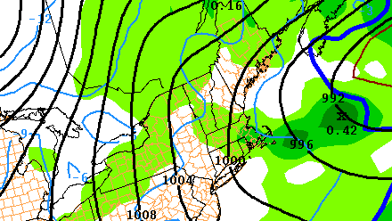
Most of Southern New England received more than an inch of rain Wednesday as a powerful storm system moved through. Record daily rainfall totals were set at the four major climatological sites in Southern New England. The wind gusted to near 50 mph at the coast. The brunt of the storm has moved on, but there will continue to be impacts for the rest of the workweek as the upper-air disturbance slowly moves east over the Northeastern United States.
Wednesday night will be cloudy and damp, with some patchy fog. The temperature will settle back into the mid to upper 30s overnight. The wind will relax to 5-10 mph. There may be some breaks in the cloud cover through midday Thursday. If some sun develops, the temperature may jump to near 50 degrees. If there is no sun, the high will be in the mid to upper 40s. A disturbance rotating through New England will kick off some rain that mixes with or changes to snow Thursday night. At this point, it is difficult to know exactly where there this relatively narrow band of precipitation will form, and it’s possible that it does not impact all of Southern New England.
The areas that see snow Thursday night could pick up an inch or two by dawn Friday. The best chance of any accumulating snow is away from the coast where it will be a few degrees colder, but, as mentioned, it’s uncertain if the precipitation will be steadier inland or near the coast. In any event, lingering showers on Friday will gradually dry out by Friday night. Highs Friday will be in the upper 30s to low 40s.
The weekend looks dry and cool. Highs will be within a few degrees of 40 both Saturday and Sunday. Right now, Saturday looks like the warmer of the two days. Both days will be partly cloudy. Looking ahead to early next week, the weather will not change very much Monday or Tuesday. There is the chance of a few rain/snow showers with highs in the upper 30s – cool for early-March. There are signs that an ocean storm may come close enough to bring rain and/or snow in the middle to latter part of next week.


