
Blizzard Watches in effect for RI, CT, and SE MA will likely be changed to Blizzard Warnings later today as the likelihood of a powerful, possibly paralyzing, blizzard increases in Southern New England. There is little doubt that there will be a major snow storm in the Northeast, but it remains to be seen if it will become one of the all-time great snow storms in Southern New England. The potential is there for it to be a top-5 snow storm for the big cities of Southern New England. Those snow records date back more than 100 years. With such great potential for a huge blizzard, it is a good idea to make sure you’re prepared for the worst. Thursday is the day to do it because the snow will be developing Friday morning, and picking up in the afternoon.

Storm Timeline
Snow will overspread Southern New England Friday morning. It will likely not be heavy initially, but the intensity should pick up in the afternoon, and by the evening commute there will likely be moderate to heavy snow falling in most of Southern New England, with some rain/mix possible right on the coast, Caped Cod, and the Islands. It’s a close call on the precipitation type near the coast, and it’s heavily dependent on the track of the storm. A 25-50 mile difference in the storm track could make the difference between snow and rain in those areas.
The wind will be increasing during the day. On the graphic, the higher end wind numbers represent the peak winds near the coast in each timeframe. It will be breezy near the coast by mid-morning, and windy mid to late afternoon. The strongest winds in RI area likely Friday night and Saturday morning. Strong winds will continue in far Eastern MA through Saturday. The strongest winds from the storm will probably occur late at night through mid-morning Saturday. Peak gusts near the RI coast should top 60 mph, with the potential to reach 70 mph. Peak gusts in SE MA will be even stronger with 70 mph likely, and the potential to reach 85 mph.
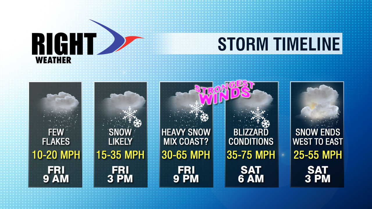
The heaviest snow will end by mid to late morning in RI, but snow bands capable of producing accumulating snow will continue into the early to mid afternoon. The snow will linger for a while in Eastern MA, and snow bands may still be producing accumulating snow as the sun is setting.
It will turn very cold by dawn Sunday. The temperature will drop from a high in the 20s to the single digits by late at night. If the wind dies and skies are clear, some inland locations could approach zero.
Coastal flooding is a big concern for Southeastern Massachusetts. Some areas will experience moderate to major flooding during the astronomical high tides Friday night and Saturday. Check out the interactive Flood Advisories map on rightweather.net.
Snow map on page 2….


