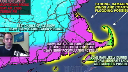
Unless there are major changes to the forecast in the next couple of days, Southern New England is in for at least the biggest winter storm of the season, and possibly among the biggest on record. Conditions are ripe for a textbook Nor’easter to develop south of Southern New England late Friday and move northward to just southeast of Nantucket by Saturday morning. The storm will drift away from the coast on Saturday, but not before bringing heavy snow, very strong winds, and some coastal flooding to Southern New England.
The first Right Weather accumulation map for this event was issued today. The potential exists for a widespread 10-20″ snowfall. The National Weather Service has issued Blizzard and Winter Storm Watches.
In the video below, Right Weather Meteorologist Fred Campagna has the latest on the weather setup and what to expect from the storm in Southern New England.
Weather enthusiasts and those who depend on the weather for their business can get even more access and information by subscribing to Right Weather Pro. The Live Blog during the storm will only be open to http://rightweather.net/join-right-weather-pro/ members. The cost is less than $.10/day and includes much more than just storm analysis and the Live Blog. Check it out!


