Spring is less than four weeks away, but it still feels like mid-Winter in Southern New England. The temperature Thursday afternoon struggled to reach 30 degrees inland, and it barely made it above freezing near the coast. The gusty northwesterly breeze kept wind chills in the teens in many spots. At least there was plenty of sunshine, and the sun angle is noticeably higher than it was a couple of months ago at the start of winter.

It will be chilly Thursday night under clear to partly cloudy skies with a weakening breeze. The temperature will fall into the low to mid 20s this evening before leveling off after midnight. Friday should be a pretty nice day, with some sunshine, and highs in the upper 30s to low 40s. There will not be much of a breeze.
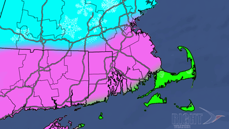
Rain and snow from the weekend storm
A storm that is hammering the Midwest with near-record snowfall totals in Kansas will move north into the Great Lakes by late Friday night. At the same time, energy from the southern branch of the jet stream will be spawning another storm over the Southeast. That’s the storm that we need to be concerned over the weekend as it heads north through the Mid-Atlantic into the Atlantic Ocean south of Southern New England. As we outlined in a separate update earlier Thursday, the setup is not the same as it was for either of the past two weekend storms. It’s also not ideal for heavy snow near the coast of Southern New England.
Right now, it looks like there will be enough mild air, at least for the first half of the storm, to bring rain from the coast to the I-95 corridor late Saturday afternoon into late Saturday night. From about the MA Pike north, there is a reasonable chance that the entire storm is snow, with another significant accumulation possible.
The toughest part of the forecast is the potential for accumulating snow on the backside of the storm late Saturday night through midday Sunday. Some computer models project several inches of wind-driven snow Sunday morning for most of Southeastern New England. It is rare to see such heavy snow accumulation after heavy rain in these areas. Normally, when the storm is warm enough to allow for several hours of rain, then the storm tracks far enough north to push the heavier precipitation to the north, and by the time the colder air arrives, there is not enough precipitation left for heavy, accumulating snow. Several computer models indicate this time may be the exception in Southern New England, but we’re not convinced yet.
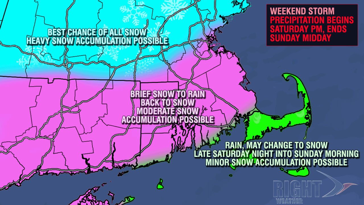
On the Right Weather storm impacts graphic, the blue shading has the best chance of a 6″+ snowfall as the storm doesn’t get far enough north to push the rain/snow line into those areas. The pink shading is an area that will likely see several hours of rain, but has the potential for several inches of snow after colder air arrives early Sunday morning. Again, we are somewhat skeptical of this, and, right now we feel that the accumulations will be modest, with the best chance of plowable snow in the northern part of this color shading. The green shaded areas are most likely to see mainly rain from the storm.


