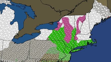
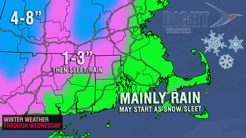
Tuesday should stay dry in spite of prevalent clouds, especially during the afternoon. The temperature will climb into the low to mid 40s after starting the day in the upper 20s to low 30s. Clouds will thicken and yield precipitation Tuesday night. Snow and mixed precipitation will move in by late Tuesday evening and continue after midnight. There will be a quick change to rain near the coast as an easterly wind brings in milder air. The precipitation will most likely change to rain by the morning commute in the I-95 corridor. Up to an inch of snow/sleet accumulation is possible from the coast to I-95 prior to the changeover.
Farther inland, the cold air will hang on for a while, and a few inches of snow could accumulate by the morning commute. The best chance of seeing 2-4″ of snow is in the northwest corner of RI and in Worcester County. Any snow will change to sleet/rain in NW RI by mid-morning, and only the highest elevations of Worcester County will continue to see snow into the late-morning hours on Wednesday. Farther west, in the Berkshires, there will be several inches of snow, possibly 6″ or more. The rain that comes after the wintry precipitation in Southeastern New England will be steady on Wednesday. It looks like a miserable day, with temperatures in the upper 30s to low 40s, a gusty easterly breeze, and the potential for 0.75-1.25″ of rain. Winds may gust over 40 mph near the coast.

Unsettled end to the workweek
Low pressure will be moving over Southern New England on Thursday resulting in lots of clouds and a few showers. The temperature will be dependent on the exact track of the storm. If it’s far enough north, then the temperature will reach the mid to upper 40s. If it stays south, then the temperatures will be in the upper 30s to low 40s. As the storm departs, colder air will wrap around it, and a period of rain and snow may develop Thursday night into Friday. It’s too early to say if there will be accumulating snow on Friday, but a few inches inland can’t be ruled out.
Dry, cool pattern into next week
The weekend looks mainly dry, brisk, and cool. Highs will be in the upper 30s to low 40s, lows will be in the upper 20s, and the breezy will be out of the north-northeast at 10-15 mph during the day. It will most likely be partly to mostly cloudy both days, and snow showers could develop by Sunday afternoon. Right Weather Pro subscribers can check out the Long Range Forecast for more details on the weather pattern for the next two weeks.


