Spring starts this week, but it sure is not going to feel like it in Southern New England. A chilly weather pattern will persist all week, and there is some snow, mix, and raw rain in the forecast for good measure. The week will get off to a cold start with lows in the teens to mid 20s Monday morning under clear skies. It will stay mostly sunny and chilly through midday before clouds advance in the afternoon. Highs will be in the 30s – about ten degrees colder than normal.
Snow and rain Monday night into Tuesday
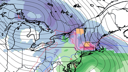
A storm will bring snow and rain to Southern New England Monday night and Tuesday. The storm will take a track that would not be favorable for exclusively snow at any time of the year, but there should be enough cold air at the onset of the storm that most of Southern New England sees snow – and it will accumulate inland. Snow will develop late Monday evening or just after midnight, and it will continue through then night.
The surge or warmer air colliding with the well-entrenched cold air over Southern New England will lead to moderate to heavy precipitation late Monday night. Right now, it looks like that will be mainly rain at the immediate coast, mainly snow inland, and snow changing to rain or sleet in the I-95 corridor. Before any changeover takes place, a couple of inches could accumulate in most of RI and SE MA. NW RI, NE CT and interior E MA, could pick up four inches of snow before a changeover. Farther inland, the snow will continue to pile up. This presents potential problems for most of Southern New England during the Tuesday morning commute. There will be a wintry mix or snow inland, and chilly rain near the coast and in the I-95 corridor. While it will likely not be a horrendous commute, the weather should be nasty enough to slow it down.
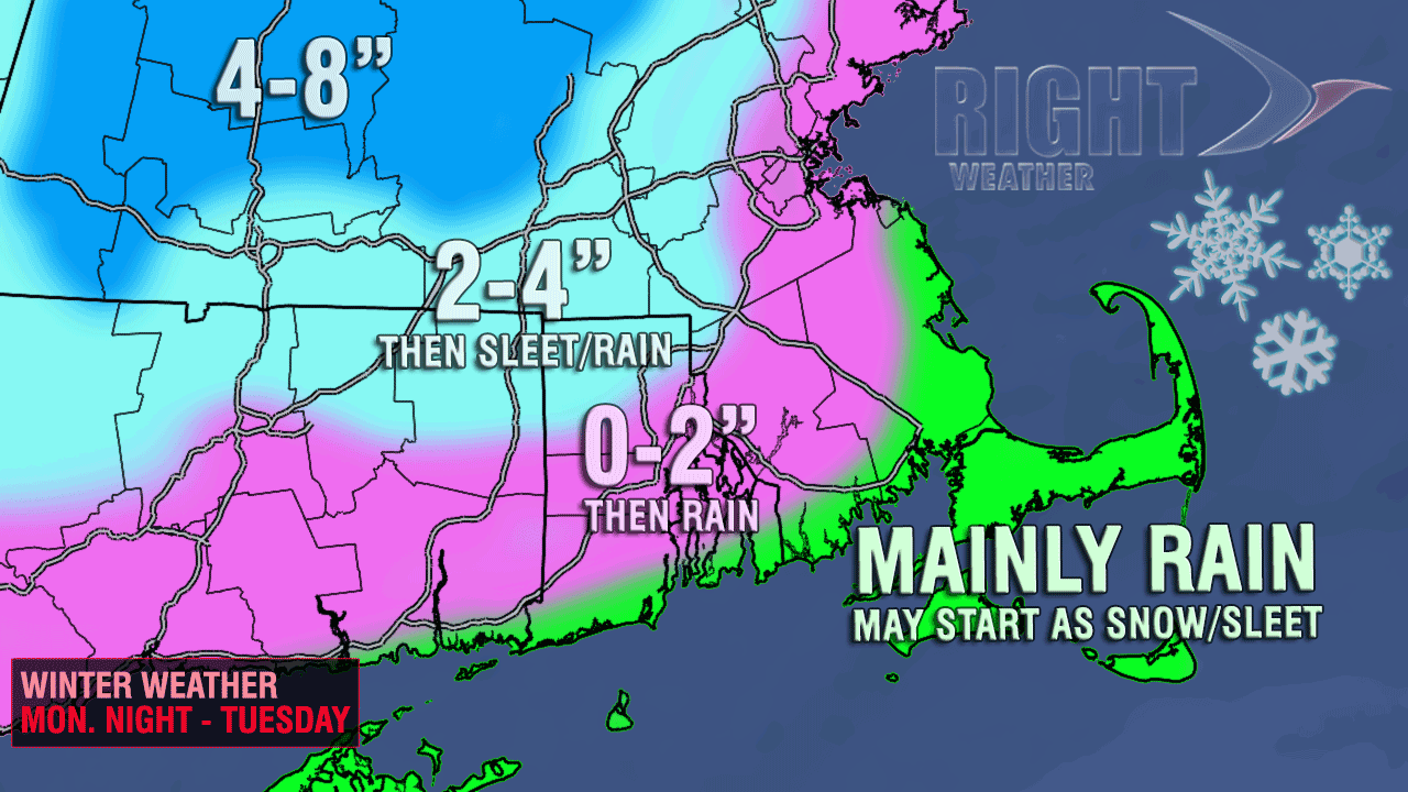
Rain will continue in Southeastern New England through Tuesday morning before tapering off in the afternoon. Highs will only be in the 30s to low 40s. The wind does not look like a huge factor with this storm. The strongest winds will be near the coast late Monday night and late Tuesday afternoon. Expect 20-35 mph sustained winds, with 35-45 mph peak gusts.
Chill stays all week
More chilly weather is in the forecast after the storm departs. The weather pattern will completely ignore the fact that spring begins on Wednesday at 7:02 am EDT. Wednesday will be partly cloudy, blustery, and cool, with highs in the upper 30s to low 40s. Thursday looks mostly cloudy with highs in the upper 30s. We’ll have to watch the development of a storm closely on Thursday. It’s possible that something will spin-up and sideswipe Southeastern with snow/rain. Friday also looks relatively cold, with lows in the 20s and highs near 40 under partly sunny skies.
Looking ahead to next weekend, it is more of the same. An unseasonable chill, and mainly dry weather. Unfortunately, this weather pattern may not break for the remainder of March.


