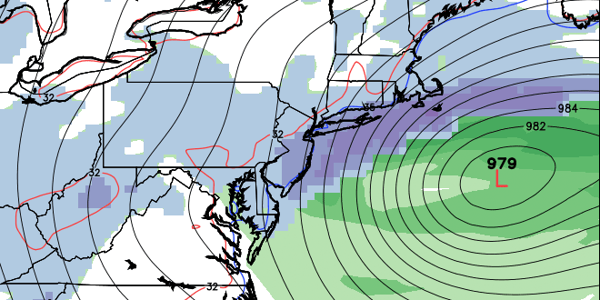
The temperature on Sunday afternoon reached 50° at TF Green Airport for the first time since March 13. It was only the third time all month that the temperature has reached 50. Overall, it was probably the nicest day of the month so far, with plenty of sunshine and a much lighter breeze than Saturday. While Southern New England was enjoying some nice weather, it was rather nasty in the Midwest and Mid-Atlantic as a double-barreled storm system hit with rain and snow. That storm system is likely to move south of Southern New England early in the week. It looks like it will be just far enough south that RI, MA, and CT will be spared any significant snow – but, it’s a very close call for the coast.
Clouds will increase late Sunday night into early Monday, and it should be overcast by mid-morning on Monday. The low temperature will be in the low to mid 30s early Monday morning. The temperature will rise into the low to mid 40s by noon. As the storm develops south of Southern New England, the wind will increase out of the northeast. By late in the day, the wind will be 15-30 mph, with the strongest gusts near the coast. There is the chance of light rain/snow developing Monday afternoon – especially near the coast.

The best chance of accumulating snow is near the coast Monday night. At this point, it does not look like more than a dusting to two inches, mainly on the grass, from the coast to Providence. There may be a bit more accumulation on the islands if the temperature drops to near freezing. The strongest winds are also likely to be on the islands, with some gusts over 45 mph possible Monday night. Low temperatures will be in the low 30s Monday night.
The storm will move away from Southern New England by early Tuesday morning. Tuesday looks partly to mostly cloudy with the chance of a few light showers. Highs will be in the low to mid 40s. The weather pattern looks similar on Wednesday through Friday. Cool air overhead will lead to some afternoon clouds, and there may be a few pop-up scattered showers. Highs will be in the 40s, and lows will be in the low 30s.
A weak disturbance will move through on Saturday. A few showers may develop during the day as that passes, but, once again, it certainly does not look like a washout. Highs will be in the 40s. The early outlook for Easter Sunday is looking decent. At this point, we’re forecasting sun and clouds with highs in the low to mid 50s – very typical for late-March.


