A major late-winter Nor’easter will hammer Southern New England from late Wednesday into Friday. The slow-moving storm will come close enough to bring heavy precipitation, damaging winds, and coastal flooding. As with most late-season winter storms, there is a very fine line between soaking rain and heavy, wet snow. In this case, it looks like those close to the coast will be spared the heaviest snow, but it is a very close call in the I-95 corridor – especially near Providence and Boston.
The inland locations have the potential for more than a foot to accumulate in the hardest hit areas. The snow will not be light and fluffy, and when combined with strong winds, could caused downed tree limbs and power lines. There is a chance of widespread power outages in Southern New England during this long-duration storm.
The timing on the storm is from late-Wednesday into Friday morning. It’s hard to say when the peak of it will be because of the uncertainty with the storm track. Moderate to heavy precipitation is possible late Wednesday night into Thursday night.
Click here for a video update outlining some of the forecasting challenges with this storm.
Download the free RIGHTWX app for your iPhone, iPad, or Android device now.
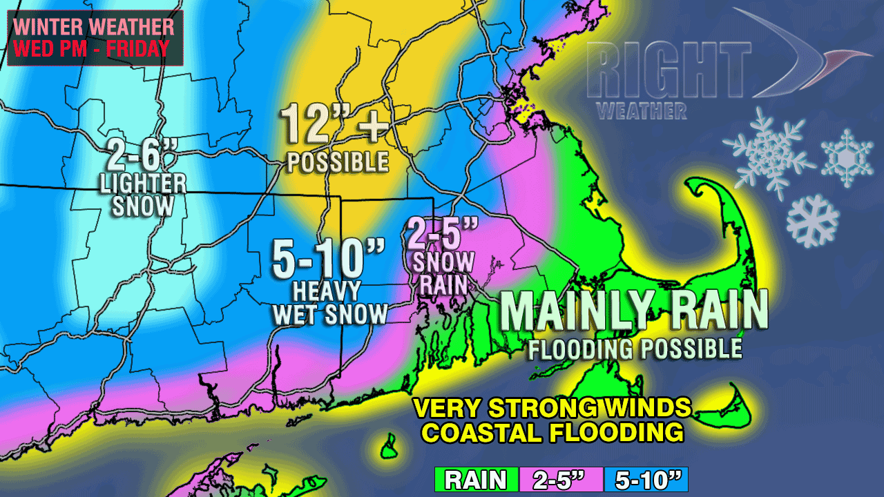
A few things to note when looking at the accumulation map.
- The distance between mainly rain and 12″+ possible is only about 25 miles. That’s fine line between getting buried and still seeing bare grass.
- All of the accumulation zones can shift in any direction based on the track and intensity of the storm. It’s still possible for the area of mainly rain to make it all the way inland to Providence and Boston, and it’s still possible to see the 12″+ snow shift in to interior SE MA.
- The snow ranges are fairly wide based on the uncertainty with the storm track and a March snow event. It’s not only tough to say if it will be snow or rain, but it is also very difficult to determine how well it will accumulate – especially during the day with a high sun angle.
- The best chance of accumulating snow is at night.
- The long-duration storm and persistent northeast winds will lead to significant beach erosion on east-facing shorelines in New England.
- Moderate coastal flooding is possible at the time of high tide for several cycles from Wednesday night through Friday.
- The snow will be wet and heavy, and anything more than 6″ will likely lead to downed branches, trees, and power lines – leading to some power outages
- The wind may be strong enough near the coast to also cause power outages. Sustained winds on Cape Cod may be over 30 mph from Wednesday evening through Friday afternoon.