A freak snow event brought more than six inches of snow to parts of SE RI and SE MA Thursday night as a trough hung behind an ocean storm leading to localized heavy snow in Southern New England. While the accumulating snow had ended for all but Cape Cod by dawn Friday, chilly weather and a gusty breeze is in the forecast for Friday afternoon. It will become partly sunny, with highs near 40, and a 10-25 mph westerly wind. There is the chance of some passing flurries Friday afternoon and evening. The sky will clear Friday night, with temperatures dropping into the mid to upper 20s by dawn Saturday.
Saturday looks brisk and cool for late-March, with highs in the low to mid 40s under mostly sunny skies. There will be a 15-25 mph northwesterly breeze that diminishes to 5-15 mph after the sun sets. The temperature will dip into the upper 20s again Saturday night. Sunday should be one of the nicer days in Southern New England so far this month. Highs will be in the mid to upper 40s with plenty of sunshine and a light northwesterly breeze.
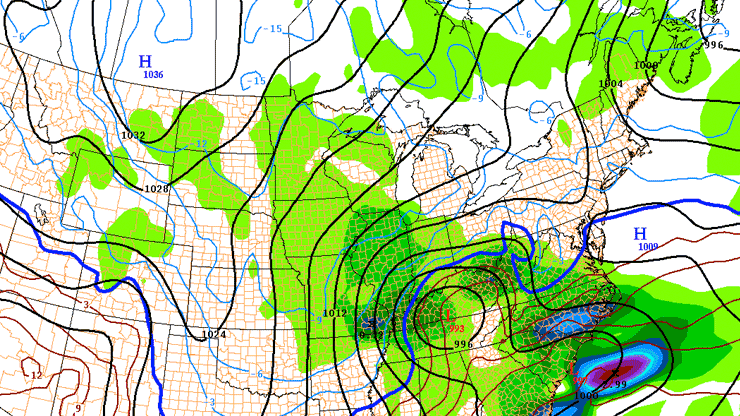
Close call with more snow Monday
We are very closely monitoring the potential for a storm in Southern New England on Monday. The storm will develop in the South Central and Midwest this weekend before moving to the Mid-Atlantic coast by Sunday night. It may come close enough to bring gusty winds and snow to Southern New England on Monday. With the temperature expected to be near or above freezing, and the high late-March sun angle, it is unlikely that the snow would rapidly accumulate during the day when the heaviest snow would occur. The storm may linger into Monday night, and there is a better chance of accumulation once the sun sets if the snow remains steady. For those that are snow-weary, there is still a chance that the storm slides out to sea just south of Southern New England with a minimal impact in CT, RI, and MA. Highs on Monday will be in the 30s if the storm hits, and well into the 40s if it stays south of the area.

The forecast for the middle of next week looks pretty good. There is a reasonable chance the high temperature reaches 50° (close to normal) at least once between Tuesday and Thursday. The weather should stay dry through the end of next workweek.


