The temperature climbed out of the teens and 20s Friday morning and reached the low 40s in most places during the afternoon. It’s not bitter cold weather, but it pales in comparison to the very warm weather in Southern New England last March. Overall, there will not be much change in the weather through the weekend. The cool, mainly dry weather pattern will persist in Southern New England through early next week.
A storm system will move south of Southern New England on Saturday. For the most part, it will just bring some clouds and cool weather, with the chance of some flurries or snow showers late in the day or during the evening – especially near the coast. The high temperature will be close to 40 degrees. It will be dry, but chilly for the St. Patrick’s Day Parade in Newport, RI.
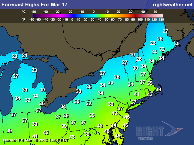
Saturday night will be cold and partly to mostly cloudy. There may be some flurries or snow showers in the evening. Lows Sunday morning should be in the 20s – ranging from about 22 degrees well inland to the upper 20s near the coast. Sunday looks bright, but brisk and cool. Highs will be in the low 40s under mostly sunny skies. The wind should relax a bit Sunday night as high pressure moves overhead. The temperature will drop into the teens to mid 20s by dawn Monday under clear skies.
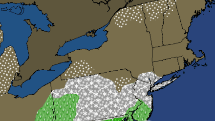
Clouds will increase Monday ahead of a storm system that will bring a mix of rain and snow to the coast by late Monday night. There should be little, if any, snow accumulation in those areas before a change to rain. Farther inland, there will likely be some accumulating snow before a change to rain. At this point, it looks like a few inches are possible in the highest terrain of NW RI, NE CT, and Worcester County before the precipitation changes to rain on Tuesday. There will be a decent soaking of chilly rain on Tuesday in Southern New England. Highs will only be in the mid 30s inland, and low to mid 40s near the coast.
The storm will depart by dawn Wednesday, and in its wake will be another shot of unseasonably chilly weather to end next workweek. It looks dry with highs in the upper 30s to low 40s. Sound familiar?


