AnalysisRight Weather Pro
Live Blog: Thursday, March 7, 2013

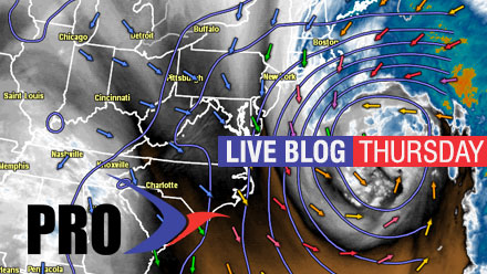
Check this page often for live blog updates from Right Weather meteorologist Fred Campagna on Thursday, March 7, 2013
Feel free to ask questions in the comment section near the bottom of the page.
Feel free to ask any storm-related questions other than “how much will we get in ______?” in the comments section. Regarding how much snow you will receive, the best answer we can give is on the accumulation map. If there is a range, that’s because of the uncertainty in the forecast.
Hi Fred! Having fun?
For Boston commuters from Cumby, would you say it could be the same scenari today, not much accumulation during the day today, but the heavy stuff tonight?
Thanks again!
If I could ask 1more thing if you have a minute, it always seems that Cumberland is on the edge of one accumulation total to the next. Is that basically because we happen to be a certain distance from the coasts of both southern RI and southeastern Mass?
All done for today asking questions! Thanks. 🙂
It’s a function of geography. Usually Cumberland is in or right on the edge of the higher snow totals when it is a high-elevation snow event. When it is a coastal event, Cumby can be right on the edge of that, too.
Any update on the “x-factor” you talked about yesterday?
See any issues w evening commute in providence tonight?
I was surprised to see no school cancellations today, especially in the NW part of the state given the high winds and wet snow we are having/expecting. Do you expect there will need to be cancellations tomorrow?
That is a different type of accumulation map. I can’t remember the last seeing the bulls eye in the location around Boston like that. This is a unique storm.
Nice to see you and Mark S trading tweets!
So… just how bad will the morning commute be, you think?