As expected, a few showers flared up over Southern New England on Friday afternoon. The morning was sun-filled and mild, with temperatures rising into the low to mid 50s by noon. Clouds that developed in the afternoon will hang around Friday night with temperatures dropping into the low to mid 30s by early Saturday morning. Saturday looks terrific, with partly to mostly sunny skies and highs in the low to mid 50s. There will be a northwesterly breeze at 5-10 mph.
The sky will be clear Saturday night, and without much wind, the temperature will drop into the upper 20s to low 30s by dawn on Easter Sunday. It will be a bit chilly for sunrise services before the temperature quickly warms to near 50 by late in the morning. It will stay sunny by midday, with some clouds rolling in during the afternoon. Highs will be in the mid to upper 50s – one of the nicest days of the month.
Rain late Sunday
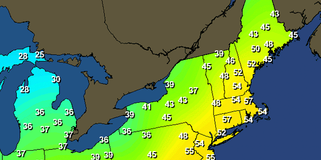
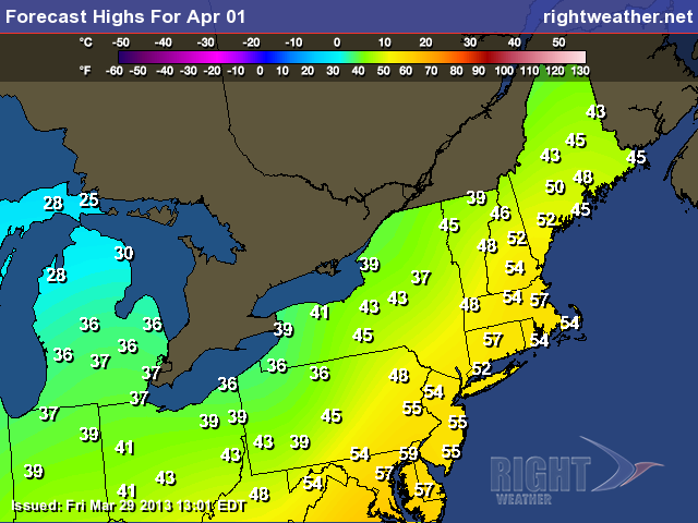
Rain showers are likely Sunday evening as a cold front approaches from the west. The rain will move through by dawn Monday, and April Fools’ Day will feature a blend of clouds and sun in advance of another cold front that will bring chilly weather back for the middle of next week. The high on Monday may reach 60 in some spots if there is enough sunshine before the second cold front arrives. Rain and snow showers will move through Monday evening opening the door to the colder weather. The temperature will drop to near freezing by early Tuesday morning.
The middle of next week looks dry and relatively cool. Highs on Tuesday will be in the mid 40s with a gusty northwesterly wind. It will be partly sunny. The temperature will drop into the 20s to low 30s Tuesday night under clear skies. Wednesday looks like the coldest day of next week, with the temperature reaching the low to mid 40s. It will be sunny with a diminishing breeze, so, all things considered, it won’t be an awful day.
The temperature starts to bounce back on Thursday with highs in the upper 40s to low 50s. The weather looks fairly quiet and seasonably mild into next weekend. We’re keeping our eyes on a storm system that will develop over the Southeast United States late next week. Right now, it looks like it will be a non-factor for Southern New England. If it stays well to our south, then the first weekend of April will feature some fine weather in Southern New England.


