Roughly one day into the March Nor’easter there is already a wide range of snowfall amounts throughout Southern New England. As of 7 pm Thursday, most spots were still waiting for the snow to accumulate or re-accumulate after melting during the day. Some places, however, have more than half a foot in Northern Bristol and Norfolk Counties in Massachusetts.
KB1CYO-Phil in Foxboro, MA reports 7.0" of snow.
— NWS Boston/Norton Skywarn (@WX1BOX) March 8, 2013
- Nor’easter Storm Timeline
- Nor’easter Video Update
- Coastal Flooding concerns in Eastern Massachusetts
- Download the free RightWX app for Android or iOS
- Check the Interactive Radar to see where the snow is heaviest
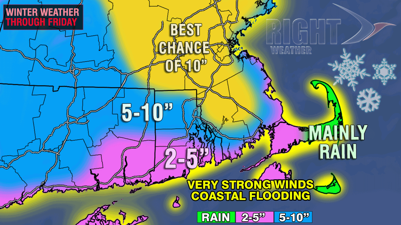
At this point, many people may be confused about what to expect on the ground when the snow stops accumulating by late Friday morning. In most cases, the Right Weather accumulation map accounts for what will be on the ground Friday, not necessarily what will fall Thursday night. Let’s break it down by region.

Rhode Island
Southern RI will pick up 2-5″ of snow overnight. Most of that will accumulate between 10pm and 6am. Central RI from Kent County to Bristol County and the Providence Metro area will likely receive between 4-7″ – not a huge snow storm, but a decent one by early-March standards. Northern RI has the best chance to see 7-10″ based on the higher elevation, colder temperatures and the fact that there was already a couple of inches on the ground in NE RI at 7pm.
Cape Cod
The forecast for Cape Cod is very tough. There may be about 6″ near the Cape Cod Canal, and nothing east of Barnstable. The Falmouth area should see 2-5″. Barnstable and Hyannis are right on the edge of mainly rain and accumulating snow. It wouldn’t surprise us to see either a few inches or bare grass reported in these areas. The wind will make it especially bad on Cape Cod – with 50+ mph gusts likely through the day Friday.
Bristol/Plymouth County Massachusetts
 Some of the highest snowfall totals in all of Southern New England may be in northern Bristol and northwestern Plymouth counties. Those areas saw a few inches of snow through mid-morning Thursday, and it did not melt during the day. With the snow already on the ground, as soon as night came, it started to accumulate again. Those areas are in the “best chance of 10″ zone” – and a few spots could end up with more than a foot. Southern Bristol and Plymouth counties will see a decent amount of snow, too. All but the immediate coast are in the 5-10″ zone, and that includes Fall River and northern New Bedford. Those cities are likely to be closer to 5″ than 10″, with the totals increasing as you head north to Taunton. Those living right along Buzzards Bay may see just 2-5″.
Worcester County east to Boston
This is a favored area for 10″ of heavy, wet snow. We’re confident that all of Worcester County and the Greater Boston Metro area will receive at least 6″ of snow, and some may get a heavy foot of snow. Snow should continue to readily accumulate until at least mid-morning in the hills of Worcester county with temperatures in the 20s.
Connecticut and Western MA
Most of Connecticut and Western MA should pick up roughly 6″ of snow. The exception will probably be in Coastal and SE CT where there may only be 2-5″. The Berkshires could see localized 8-10″ amounts.


