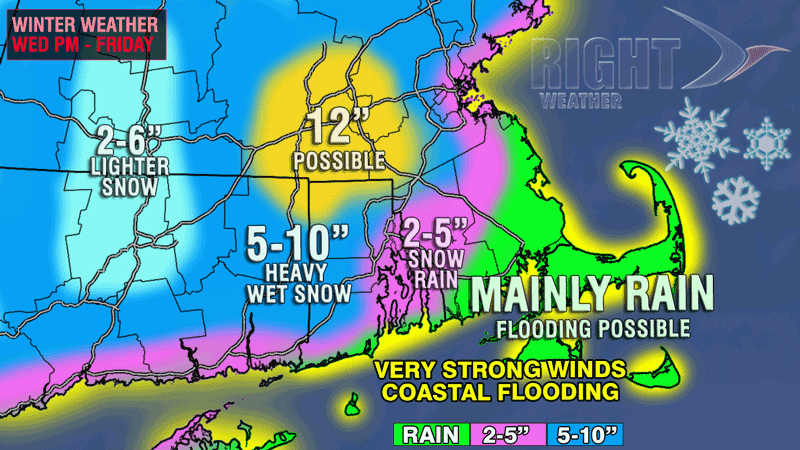
A complex weather scenario will be unfolding in Southern New England during the remainder of the workweek as a large and powerful Nor’easter spins in the Atlantic Ocean off the East Coast. The storm will come close enough to Southern New England to bring snow, rain, strong winds, and coastal flooding. Right Weather has the storm covered from start to finish, and you can get some of the latest information by clicking on the links below.
- Video Update: March Nor’easter closes in on SNE
- Nor’easter storm timeline
- National Weather Service issues Coastal Flood Warning
- National Weather Service issues Winter Storm Warning and Winter Weather Advisory
- TV station snow forecast roundup
- Live Blog: Wednesday, March 6, 2013 (Right Weather Pro)
- Download the FREE RightWX app for your iPhone, iPad or Android device right now
The accumulation map has not changed drastically in the past 24 hours. Here are a few notes on some of the nuances and uncertainty surrounding the forecast.
- We still feel the highest likelihood of heavy, wet snow is in the highest elevations of NW RI, NE CT and Worcester County. Some computer models show the highest snow totals in Southeastern Massachusetts, and that is something we’ll be monitoring very closely.
- The snow will be twice as heavy as “normal” snow because of the high water content. One inch of liquid is likely to produce about 6″ of snow instead of a foot. That will make even a relatively small amount of snow difficult to move.
- Road conditions may not be as bad as you would expect given the snowfall forecast. The snow will have a very difficult time accumulating on the main roads during the day because of the temperature in the 30s and the high sun angle. At night, there is a better chance of some snowy roads – especially those less traveled.
- The first round of accumulating snow will come Wednesday night when 2-6″ may fall in most of RI and interior SE MA. There may not be much additional accumulation during the day Thursday due to the temperature and sun angle. There could even be a change to rain in the Providence area.
- A disturbance entering the storm system late Thursday (see the video update) will be the x-factor for more accumulating snow inland Thursday night into Friday morning. There is a lot of uncertainty concerning exactly how that will play out, and the best chance of flipping back to accumulating snow is in the higher terrain.


