
11 AM UPDATE
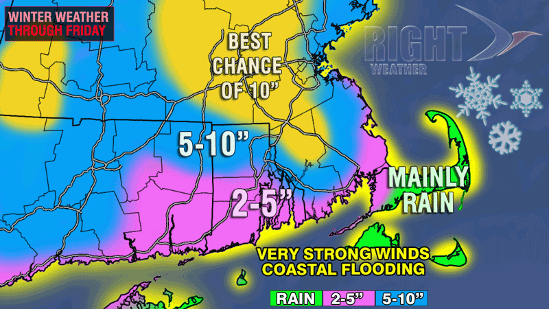
 Snow of varying intensity will continue through this afternoon. The temperature in the low to mid 30s combined with a high March sun angle should limit daytime accumulations on pavement. Once the sun sets, however, the temperature will drop a couple of degrees and the loss of insolation should allow for accumulating snow. A period of moderate to heavy snow is possible tonight, with the favored area for heavy snow in interior SE MA back to Worcester County and part of Providence County in RI. The accumulation map below has been updated to account for the changing forecast. Areas that receive more than 6″ of snow will be susceptible to downed branches, trees, and power lines – especially when the snow weight is combined with wind gusts over 40 mph.
There was minor/moderate coastal flooding in Eastern MA Thursday morning at the time of high tide. The flooding and beach erosion should be similar during Thursday evening’s high tide, and will likely be worse during Friday morning’s high tide.
- Thursday Live Blog
- UPDATED TV station snow forecast roundup
- National Weather Service expands Winter Storm Warning
- Interactive map with coastal flood advisories
FROM 7AM UPDATE
The powerful March Nor’easter has put a thin blanket of white over most of Southern New England by dawn on Thursday. Temperatures are at or above freezing in most areas, but the precipitation is in the form of snow in most of RI, MA, and CT. As of 6 am, the only rain was on Cape Cod and Nantucket. It looks like colder air aloft will allow for more snow than previously expected to fall in interior SE MA. This scenario was outlined in an update Wednesday evening. While the snow totals are unlikely to be extremely high from this event, the heavy, wet nature of the snow could down some branches and power lines over night Thursday into Friday morning when the steadiest accumulating snow is expected.
Snow is likely all day Thursday. The intensity will vary, and combined with the high sun angle, there may not be much accumulation during the day. Snow will continue Thursday night, and the best chance of steady, accumulating snow is Thursday night into mid-morning Friday. The wind will continue to howl through Friday morning. Peak gusts near the coast will be 50-60 mph, and inland peak wind gusts will be 40-50 mph. Sustained winds will be 20-35 mph.
Coastal flooding is likely at the time of high tide in most of Southern New England. It will probably be the worst along the Eastern MA coastline and on Nantucket.
Let the flooding begin, Scituate. pic.twitter.com/qt8gC2bLRP – @KarenWBZradio
— WBZ NewsRadio (@wbznewsradio) March 7, 2013


