Saturday was an interesting day weather-wise in Southern New England. Afternoon temperatures ranged from the mid 30s in Southeastern Massachusetts to the mid 50s in Western RI, CT, and MA. The wind off the ocean kept SE MA quite a bit cooler, and that will be a theme for the next few months any time the wind is off the ocean. The wind will relax Saturday night, and it will be rather cold, with lows in the low to mid 20s. Some of the outlying areas with a thick snowpack could see the temperature dive into the teens.

Sunday looks pretty nice, with a blend of clouds and sun, a light breeze, and highs in the mid to upper 40s. It will stay nice, and probably be warmer, on Monday. The high temperature should crack 50 in some places by early in the afternoon. It will be cooler at the coast because of a southerly wind. The sky will be partly sunny.
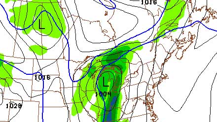
The best chance of precipitation this week is on Tuesday, and it should be rain. The temperature will stay in the 40s/50s as a cold front approaches from the west on Tuesday, with showers likely Tuesday afternoon and evening. Cooler and drier weather will arrive Wednesday and stay through Thursday. Right now, it looks like it will stay dry and cool into next weekend, but we’ll have to keep an eye on a weather system moving through Mid-Atlantic late in the workweek.


