The weather will not change drastically for the second half of the weekend. There should be a bit more sunshine, especially near the coast on Sunday afternoon, but the temperature will once again be in the upper 30s to low 40s. It will be breezy through midday, with the wind relaxing by early in the evening. High pressure will move overhead Sunday night, and skies will be clear with temperatures falling into the low to mid 20s by dawn on Monday.
Monday will be mostly sunny through midday. It will, however, be unseasonably chilly, with highs only in the mid to upper 30s. There will not be much of a breeze. Clouds will roll in late in the day. A complex storm system consisting of two separate areas of low pressure moving west to east from the Midwest and Great Lakes into the Northeast will bring snow and rain Monday night through Tuesday. The best chance of accumulating snow is in the highest terrain of Southern New England. Flakes will fly in the big cities of Southern New England late Monday night prior to a change to rain on Tuesday. A first look accumulation map is available for Right Weather Pro members.
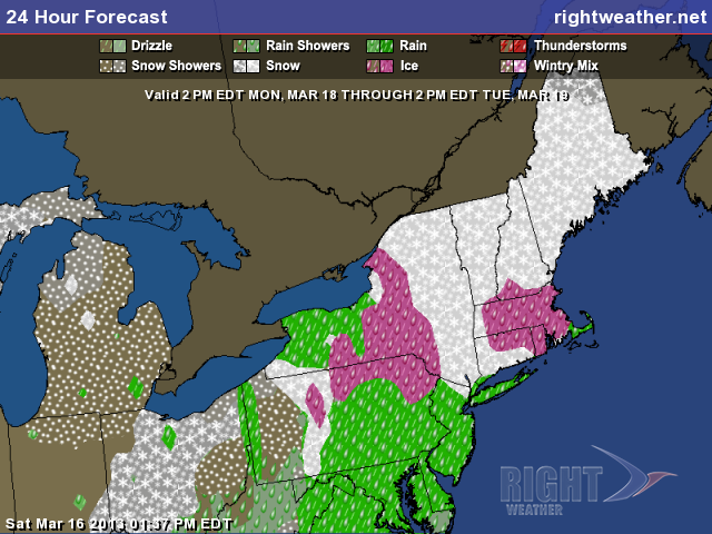
The storm may have an impact on the Tuesday morning commute, especially away from the coast. As the storm gets closer, slightly milder air will move in and change any snow to sleet and rain. It will be a raw day with highs in the 30s to low 40s. Precipitation should wind down by late Tuesday. The storm will bring mainly snow to interior New England, with the mountains of Northern New England picking up another healthy dose of fresh powder.
The weather in the wake of the storm will be chilly for the first day of spring on Wednesday. Spring officially arrives at 7:02 am EDT on Wednesday, but it will feel more like winter with temperatures in the 20s on Wednesday morning. Wednesday afternoon does not look much warmer, as the temperature will struggle to reach 40 degrees again. A weaker storm may sideswipe coastal Southern New England with some rain/snow on Thursday before another surge of chilly weather moves in for next weekend. The weather pattern for the first week or two of spring looks a lot more like February than late-March.


