March got off to a quiet start in Southern New England. The high temperature under partly to mostly cloudy skies at TF Green Airport was 49° – one degree warmer than any day in February. Overall, February was a bit colder than normal with a lot of snow and precipitation. The winter as a whole was a bit warmer than normal, with more snow and precipitation than normal.
March is known for its wild weather in Southern New England, but the first weekend of the month should be fairly quiet. There will be partly to mostly cloudy skies Saturday and Sunday. Highs should be in the low 40s both days, with overnight lows in the upper 20s. It should be nice running weather for the Irish 5k in Pawtucket on Saturday morning. The weather will stay quiet early next week before a storm threatens in the middle of the week. Monday and Tuesday should both feature partly sunny skies, with highs in the low to mid 40s.
Significant midweek storm possible
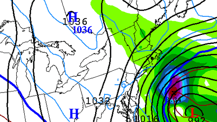
There are many questions surrounding the development and track of a potentially big storm in the middle of next week. Some computer models bring a storm to the Mid-Atlantic coast that delivers strong winds, heavy rain and snow, and coastal flooding to the Northeast including Southern New England. Other models have the storm staying just far enough south that it is not a big factor in Southern New England, with a much larger impact in the Mid-Atlantic states.
At this point, the forecast calls for increasing clouds early Wednesday, with the chance of rain/snow and strong winds Wednesday into Thursday. If the storm comes close enough to bring steady precipitation to all of Southern New England, the best chance of seeing wet, heavy snow is away from the coast. The strongest winds are likely to be near the coast.


